Snow Storm

Snow Storm Forecast to Hit Watertown Area This Weekend
|
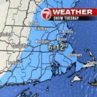
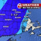
A storm with snow, sleet and possibly ice will roll through the area on Saturday evening into Sunday of Martin Luther King Jr. Day weekend. A Winter Storm Watch has been issued for all of Massachusetts by the National Weather Service. Up to six inches of snow is possible in the area, according to the NWS warning, and ice accumulation is possible. The storm follows the coating of snow expected to fall Friday morning. WBZ Channel 4 weather forecasters anticipate snow to start around 8 p.m. on Saturday and the heaviest snowfall overnight.