National Weather Service

Strong Thunderstorm Hits Watertown, Concert Moved Inside
|
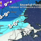
A thunderstorm rolled through Watertown on Wednesday, causing some damage. A powerful thunderstorm blew through Watertown Wednesday afternoon, damaging some trees and moving the Watertown Summer Concert inside. The National Weather Service issued a Severe Thunderstorm Watch until 9 p.m. on Wednesday. The storm hit Watertown shortly after 3:30 p.m.
A tree branch on Westside’s Brandley Road reportedly fell on utility poll during the storm on Brantley Road. Firefighters found live electrical wires on the street, and called for an Eversource crew to come repair it.