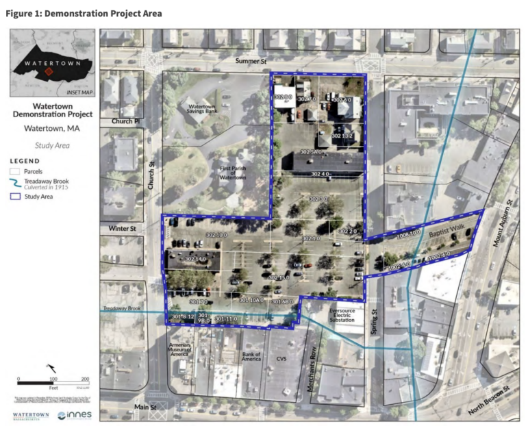
Detailed plans for redeveloping Watertown’s Municipal Parking Lot in Watertown Square, behind CVS, are included in the City’s draft plan for the Demonstration Project. The 163-page document outlines two options, both of which include a multi-story parking garage, a multi-story residential building (both with retail on the ground floor), and a public green space.
City Manager George Proakis gave an overview of the redevelopment of the lot, which would require buying or taking by eminent domain of several properties, at a packed meeting in the Watertown Free Public Library. The presentation did not include many details, however the draft plan includes a ream of information about the options, the cost, and the timeline.
On Monday, Proakis said the City has started discussions with developer Hg80, which has an agreement with the owner of multiple properties that would need to be included to do the project as laid out in the Plan.
The draft Watertown Square Demonstration Project Plan was released Wednesday, and includes many details about the housing, parking garage, traffic patterns, a timeline, finances, which boards make decisions, and much more. The Draft Plan was created by the City of Watertown staff along with consultants Innes Land Strategies Group, RKG Associates, and Tighe & Bond.
The Demonstration Project will start to put the recommendations of the Watertown Square Area plan into action.
The Plan reads: “This document builds on the conceptual plans developed in the Watertown Square Area Plan by focusing on the first recommendation: a public/private partnership to redevelop the City-owned parking lots in the heart of Watertown Square. This Demonstration Project Plan provides a proof-of-concept for other developers in the area by addressing the Square’s need for housing to support local businesses, creating a green gathering space, enhancing pedestrian and bicycle infrastructure, incorporating energy- and water-efficient design, and providing public parking.”
The Options
The two options are similar, but vary in size. Both have the parking garage on the western part of the lot, and on top of what is now the Gray Block (home to Tresca’s Eating Place, a salon and a laundromat), and the residential building on the north and east corner (including the former Registry of Motor Vehicles building and four houses on Spring and Summer streets). The public open green space would go on the southeast portion of the parking lot, along Spring Street. Proakis said the options for layout are reduced due to the City of Cambridge’s aqueduct running through the site. The Community Path will go through the site, too.
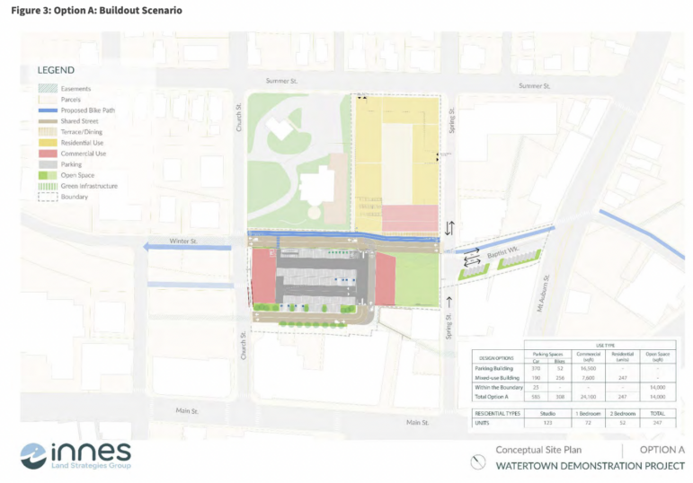
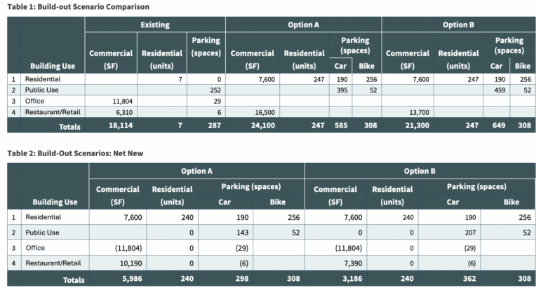
Two options are outlined in the document, and both included a residential building with 247 housing units — with a mix of studios, one-, and two- bedroom units — and 190 parking spaces. The size of the parking lot varies. Option A has 370 parking spaces for motor vehicles in four stories, while Option B has 434 spaces in a five-story structure. The current surface lot has 252 spaces. Both options include 52 bicycle parking spaces.
The Plan reads: “In all scenarios, parking in the garage exceeds the current condition while reducing the overall footprint of impervious surface. This also allows for increased off-street overnight residential parking during the City’s winter on-street parking ban periods.”
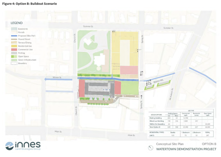
Option A includes 6,500 sq. ft. in ground floor retail, plus a two-story, 10,000 sq. ft. commercial annex building. Option B has 4,900 sq. ft. of ground floor retail and 8,800 sq. ft. of space in the two-story commercial annex building
The residential building in both options is a 293,897 sq. ft. mixed-use building including 7,600 sq. ft. of ground-floor commercial space, which would face the bike path and the 12,300 sq. ft. green space. The mixed-use building would include a parking area, with one entrance on Spring Street on the first floor and another on Summer Street accessing the second floor. There would also be 256 bike spaces.
According to the Plan: “The proposed mixed-use buildings feature ground-floor retail or other active uses, accompanied by upper-floor residential units. The proposed commercial uses in the parking garage include restaurant and retail, with ground-floor and upper-floor units. Office use is not shown, but it is not precluded. Parking for all uses in this scenario is included in either the parking garage or the residential building.”
An access road for the parking garage would be built on the south side of the parcel, with two-way traffic. The project also includes changes to Baptist Walk, the roadway between Mt. Auburn and Spring streets. That roadway is proposed to become a two-way street along with space for the shared bicycle and pedestrian path. Another proposed change is to make Spring Street two-ways from Baptist Walk north to Summer Street (it is currently one way headed away from Main Street between Main to Summer).
The City provided links to read the Demonstration Project Plan Draft (click here) and submit Comments & Questions to Staff (click here).
Timeline
The Plan summarized the steps in completing the Demonstration Project.
“This process begins with the City Council, sitting as the Redevelopment Authority, adopting the plan, followed by a separate approval from the City Council,” the Plan reads. “Once the plan is adopted, the process of creating an RFP [request for proposals] and seeking development partners will begin, followed by the acquisition and disposal of the required parcels to implement the plan and the negotiation of a development agreement with the chosen developer(s). The estimated timeline outlined in Section 3.5 would see construction begin in 2029, with the garage and new units set for final operation in 2031.”
The adoption of the Demonstration Project Plan takes place in 2026 in the draft, followed by pre-development in 2026 and 2027.
“This phase involves identifying development partners, developing financial strategies, and pre-planning necessary capital improvements,” the Plan reads. It also mentions the City may send out a Request for Proposals (RFP) for developers during that time.
Phase 3 would be acquiring and disposing of properties, including relocating residents and businesses displaced by the project. This phase is scheduled for 2027 to 2029.
Design and construction fall in 2029 and 2030 in the timeline, and the garage, commercial buildings and mixed-use building would begin operating in 2031, according to the draft Plan.
Approval Process
The City Council has a dual role, as the Council and the Redevelopment Authority. The Planning Board and the City’s legal counsels will also have a role in the approval process.
The Plan outlined the roles and responsibilities.
“The City Council is responsible for adopting any zoning changes that the City may undertake in response to the recommendations in this Plan. The Council also approves infrastructure improvements throughout the city and is the primary legislative authority. The Council also adopts the City budget,” the Plan reads.
The Planning Board is responsible for reviewing the projects associated with the Plan to make sure they meet the site plan review or special permit thresholds. The Planning Board would also review any zoning changes requested by the City Council.
The Zoning Board of Appeals may also have a role. For multi-family projects in the transit oriented district overlay (TODO) created to meet the MBTA Communities Law, the ZBA would approve special permits, while the Planning Board approves site plan reviews.
“The Watertown Planning Board must find that the Demonstration Project Plan is based upon a local survey and conforms to a comprehensive plan for the locality as a whole,” according to the Plan.
The City Council must hold a public meeting on the Demonstration Project Plan, and must notify the Historical Commission in advance. The Redevelopment Authority must provide a legal opinion from counsel to the urban renewal agency “certifying that the proposed Demonstration Project was adopted in accordance with M.G.L. c. 121B, § 48, and complies with applicable laws.”
Property Acquisition
The cost of acquiring the parcels in the project area is estimated to be $12.8 million. This includes the buildings such as the Gray Block, the former RMV, the homes, and also slivers of parcels from adjacent businesses and properties along the south edge of the Municipal Parking Lot and along Baptist Walk. Another $4 million is budgeted for relocation of residents and businesses, administrative costs, appraisals, and legal fees. In addition, there is an estimate cost of $2.5 million in contingency funds. The total estimate is $19.36 million.
Funds for these costs would come from different sources.
The Plan reads, “The City does not have a funding source for these acquisitions. It plans to work directly with redevelopers and property owners as they fund property acquisition, relocations, and other costs under property-by-property agreements.”
The City may be able to get funds from the Affordable Housing Act of 2024 to help pay for the housing in the mixed use-building.
The City can negotiate with property owners to try to come up with an agreement to purchase the property. Proakis said the City has reached out to the property owners and heard back from some of them. Another option is to take the land using eminent domain.
“At the end of the day, this is a tool in the planner toolbox that you use very, very carefully and in very, very limited circumstances and you work hard to try not to use it at all,” Proakis said on Monday. “I have done plenty of a revitalization plan project where we’ve never had to actually use eminent domain as a tool.”
If eminent domain is used, the owner is compensated the full market value for the property. This requires multiple appraisals and sometimes post-payment negotiations, Proakis said. The City would also provide relocation costs for residents and businesses.
Areas to be Studied
Some questions remain about the Demonstration Project, such as traffic, potential hazardous materials, and utilities in the area.
Traffic studies have not yet been done. A traffic study of the existing parking lot in November 2025, looked at inbound traffic from Mount Auburn Street to Baptist Walk, and found 25 vehicles in the morning and 109 in the evening at peak times, the Plan said.
Proakis said the asphalt in the parking lot likely covers contaminated soils. The Plan notes there could be leaks from underground gas and diesel storage tanks, and it is also possible that contamination resulted from the former industrial and railroad uses of the site, including coal, coal ash, petroleum, and/or pesticides.
The Cambridge water supply pipe is just one utility running through the project area. Others include City-owned water, sewer, and stormwater services, privately owned electricity and natural gas services, and telephone and data utilities.
Demonstration Project and Urban Revitalization
The City of Watertown is using the state’s urban revitalization law to redevelop Watertown Square. While other areas may be redeveloped, including the parking lots behind the Watertown Library and the one behind the former Santander Bank, the Municipal Parking lot behind CVS is the Demonstration Project for the rest of the larger redevelopment.
Under the law, the demonstration project must meet certain criteria, according to the Draft Plan, including:
1. The project should have the purpose of eliminating blight.
2. The project must show that new methods or techniques are being used (e.g., using innovative technologies to complete construction in a shorter time period).
3. The project should serve as an example for use in the wider area (or in other communities).
“The project area meets the definition of a blighted area due to its diverse ownership, including the tangle of easements owned by the City and others, excessive land coverage by asphalt from municipal parking lots, and the uncertainty of contaminated soils from prior industrial uses in close conjunction with underground water sources,” the Plan said.
The project area has been a parking lot for nearly 90 years, according to the Plan, and the Board of Assessors “considers the buildings in the project area to be in at least 68% good condition.” The Demonstration Project would increase the City’s supply of one-, two-, and three-bedroom units, 15% of which would be affordable.
The Plan says, “This plan demonstrates the possibilities for other downtowns of replacing the wide expanses of paving, which have detrimental environmental impacts and low tax benefits, with a development that provides significant community benefits and unlocks additional development.”
The Plan also goes into detail about why it should be redeveloped with a public-private partnership.
“(P)rivate enterprise cannot address the conditions of this plan area on its own; however, the City also cannot undertake the project without the resources of a private developer,” the Plan reads. “The City can provide land, a mechanism for land assembly (if necessary), a streamlined permitting process, and access to bonding or grant programs as the applicant. The developer can provide design and construction expertise, additional land (depending on the developer), and access to capital sources that may be unavailable to the City.”
Parking in multistory garage will be pain in the neck vs. parking at ground level currently.
I don’t understand the seemingly urgent need to build more, more, more. It’s clearly too late for public input, the steamroller this project represents is moving forward regardless of what current residents may think of it. But hey, it’ll be a feather in the cap of the leaders.
Hi Michael. I know that it’s tempting to throw in the towel, given things that you’ve seen in the past. This is just the beginning of the process, not the end. Keep being involved. Contact your Councilors…all of them! Tell your neighbors about these plans. That’s the way that your voice and others will be heard.
Watertown has already taken on significant growth. We’ve just completed three new schools, expanded/renovated another, and we’re still planning for a new middle school. Our classrooms are already full, and traffic congestion in Watertown Square is becoming increasingly difficult.
Growth needs to be balanced and sustainable. If new housing is being added, the conversation should also include homeownership opportunities for working families, along with realistic planning for infrastructure, traffic, and school capacity.
Development should strengthen our community — not outpace the systems that support it.
Hi Wendy,
You’ve clearly put some serious thought into this. Why not share your thoughts with your neighbors and friends in Watertown? Many may not even know that a large parking garage and market rate apartments are being considered.
There’ll be more meetings and more opportunities for the public to weigh in. Those opportunities are often being missed by many. Letting your neighbors know when they are occurring (how to find information is confusing for many, given the different forms information presents itself these days), could contribute to more Watertown voices being heard. Remind them to contact their councilors, who’ll be making the final decision. I think you know the drill.
Excellent comment Wendy.