Here Comes the Snow, Again – See How Much

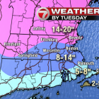
Another round of snow is on its way to Watertown, and the Boston region could get another foot or more in a long-lasting storm. The National Weather Service has issued a Winter Storm Watch starting at 1 a.m. on Sunday and ending at 1 a.m. on Tuesday. WHDH Channel 7 has Watertown in the area that will get 8 to 14 inches of snow (see above). Further north in Massachusetts and New Hampshire could get up to 20 inches, while the Cape and Southeast Mass. will get 5 to 8 inches.

UPDATED: Find Out How Much Snow to Expect in Watertown This Weekend

A storm with a mix of snow and rain will hit town early Saturday morning and the National Weather Service has upgraded the amount of snow forecast to fall on Watertown. Snow will begin falling at 3 a.m. on Saturday morning and the storm is forecast to drop 3-7 inches of snow and sleet on Watertown, according to the NWS website. Precipitation will be mostly snow before 10 a.m., then freezing rain between 10 a.m. and noon a mix of snow and rain after noon. The forecast for Sunday is sunny with a high around 34, but there is a chance of snow Sunday night and Saturday.

Snow Storm Hits Watertown Thursday

Snow covers the road at the Arsenal on the Charles in front of athenahealth. Photo: Charlie Breitrose. By Charlie Breitrose

[Updated 4:02 p.m.] The snow has turned to rain. Watch out for downed branches and power outages. The snow may return later.