
Melanie Graham
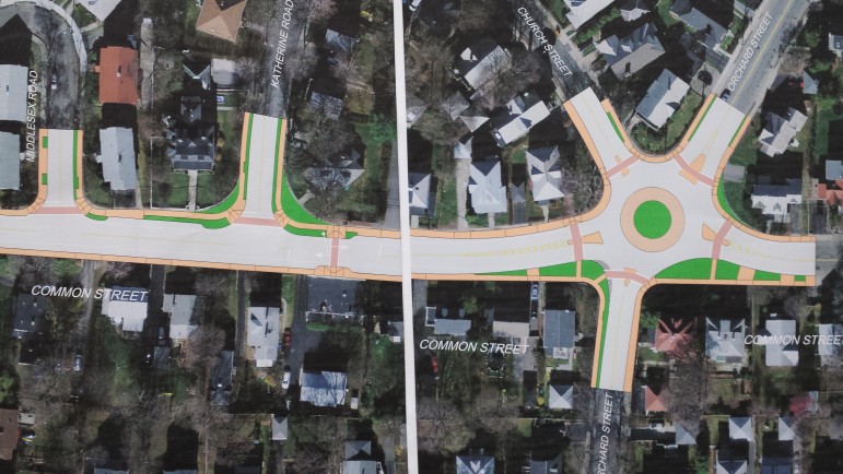
This drawing shows what the redesigned intersection of Common and Orchard streets could look like with a rotary.
Watertown officials joined transportation engineers Thursday night to present concepts for two major roadway projects that aim to improve safety for drivers, pedestrians and cyclists.
The public forum, held during a meeting of the Town Council’s Public Works Committee, provided an update on the Mt. Auburn Street reconstruction project as well as early designs for the Common Street improvement project. Residents were given the opportunity to weigh in on goals of the projects and provide feedback on design concepts.
“We are very early in the process of these projects and this is the first of many community meetings we will have,” said Councilor Cecilia Lenk, who chairs the Public Works Committee. “Nothing is set in stone.”
Public Works Superintendent Gerald Mee echoed Lenk’s comments throughout the meeting, emphasizing that there is still a long process of public feedback before any official designs are approved. Town officials were joined by engineers from WorldTech, who presented design concepts for both projects. Representatives from MassDOT, MassHighway, the MBTA and National Grid were also present, as well as many members of the Town Council.
Mt. Auburn Street Reconstruction Project
Melanie Graham
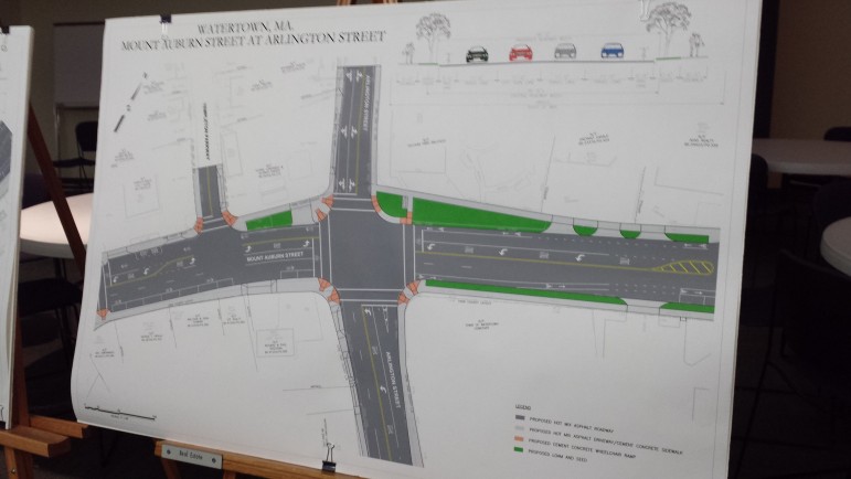
Proposed plans to redesign the intersection of Mt. Auburn and Arlington streets.
The Mt. Auburn Street project focuses on intersections east of Common Street. In the design concepts, parts of Mt. Auburn Street would be reduced down to one lane in both directions, with turning lanes added at certain intersections.
This process, called a “road diet,” reduces the number of lanes on a road to provide space for all users, including cyclists, pedestrians and public transit. Mt. Auburn Street was initially identified for a road diet in 2002, but the project was not awarded funding until April of last year.
A few residents shared concerns about the lane reduction, arguing that it would cause more traffic back-up. However, WorldTech Traffic Engineer Michael Pompili explained that feasibility studies show the traffic would actually improve with just one through lane and specific turning lanes. He also noted that the road west of Common Street, heading toward Watertown Square, would stay as four lanes.
In addition to helping traffic flow, Pompili said the road diet project would create more room for bike lanes as well as space for some turn-outs for the 71 bus. With added welcome signage, landscaping, benches, traffic calming measures and shorter crosswalks, Pompili said the overall “perception and context” of Mt. Auburn Street would appear more like a neighborhood road.
Melanie Graham
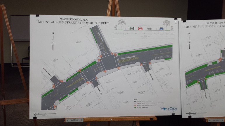
Changes may be coming to the intersection of Mt. Auburn and Common streets as part of a major redesign of Mt. Auburn Street.
Many of the residents at the meeting argued more needed to be done for cyclists and pedestrians, particularly near Hosmer Elementary School. Some suggested the addition of raised and/or lighted sidewalks and protected bike lanes. Several attendees also emphasized the need for improved bus stops that do not block traffic or driveways.
Lenk assured residents that several workshops will be held to allow town officials and residents to “dive deeply into each detail” of the project, including bike lanes, crosswalks, parking and storm-water management.
Common Street Project
The Common Street project, which extends from Mt. Auburn Street to Church and Orchard Streets, aims to improve safety by adjusting several intersections along the stretch of road.
In the early designs presented Thursday, engineers recommended:
- Common Street, Spring Street and Marion Road – A new signal would be added and the current triangle intersection would be removed.
- Columbia Street and Robbins Road – Added curb bump-outs and raised crosswalks.
- Common Street and Katherine Road – Road would be “tightened up” to reduce the crossing distance for pedestrians, vehicle stop lines would be moved back and textured crosswalks added.
- Five-way intersection at Common, Orchard and Church Streets – A single-lane rotary would be added. The rotary would allow speeds to circulate at 15-25 miles per hour.
Most of the discussion Thursday focused on the roundabout at the five-way intersection, an area Pompili referred to as a “free for all” where vehicles frequently speed. Many of the residents applauded the idea for a roundabout and agreed that it would slow down cars coming through the intersection.
Several residents raised concerns about proper bike lanes and signage for the roundabout. However, town officials and engineers reiterated that the project is very early in the process and many features have yet to be added to the design. Similar to the Mt. Auburn Street project, officials plan to hold many community meetings and workshops.
“It’s important that we’re tailoring the project to the needs of the community,” said WorldTech President Rich Benevento.
As for next steps, Pompili said engineers will continue to gather feedback from the community and draw up a preliminary engineering design. Officials will also seek funding for the project through the state’s Chapter 90 Program, which funds road repairs.
Although the presentations were held at the same meeting, the Common Street and Mt. Auburn Street projects will be bid out separately, as the estimated $12.2 million Mt. Auburn Street project will receive federal funds through MassHighway.
Regarding Mt. Auburn St.:
Reducing to 1 lane will create more issues…what happens when trucks are double parked to unload supplies at the commercial establishments? What about taking a left turn where there isn’t a turn lane? Are you planning islands like Trapelo Rd in Belmont? That’s a nightmare! PLEASE don’t follow Belmont’s example-they are the most dysfunctional when it comes to traffic. How will this affect first responders trying to get through traffic during an emergency call? Where will the cars move to, in order to let them pass?
Orchard & Common rotary: Will that be the headache that Belmont has at Grove & Blanchard? Trucks/ambulances/fire vehicles/plows can’t navigate that tight circle. Are we headed in the same direction? Ladder trucks have to be able to quickly move in these areas. We must talk/work with our first responders to make sure they are on board with these changes.
Don’t forget all the additional traffic we will have from all the new construction. 600+units in the east end WILL increase traffic. Just like our schools are now overcrowded, same for our streets. Reducing traffic flow just doesn’t make sense. You can’t “calm” traffic when are adding more vehicles everyday.
Let’s think this through very carefully BEFORE the first day of construction begins.
Very good questions, Wendy. And I’m sure a lot of people share your concerns.
Re., Mt Auburn St Project: there are massive apartment building projects in process within WALTHAM; one on the end of River St, the other, between Main St and Felton St; additionally there is another nearing completion at the intersection of North and River Streets. I believe it would be advisable to check out what other cities surrounding Watertown are involved in “development” inasmuch as Watertown is definitely the HUB involving traffic.
How can any traffic planning process be developed LOGICALLY if the traffic originating from surrounding communities is not considered; the VOLUME is not some STATIC figure, the increase is evolving geometrically
and the talk of “Diet” designs to “calm” the traffic pattern is sheer nonsense. Signed, Will Clifford
Some thoughts on bicycle lanes: has anyone ever quantified the volume of bicycle riders utilizing the Watertown road system? Have cost considerations been matched with that volume? What TAXES do the bicycle riders contribute ie., EXCISE, and GASOLINE taxes for motor vehicles….NOTHING from bicycle riders and yet, consideration is being given to expend MASSIVE amounts of funds to accommodate a volume of road users that has not been QUANTIFIED.
EVACUATION ROUTE(S) Has any consideration been given to Evacuation Routes for the population of adjacent communities to be utilized in the event of area wide EMERGENCY evacuation? I noted signage on North Beacon St on Brighton, heading toward Soldier’s Field Road just prior to entering under the Route 90 Mass Pike overpass indicating “Evacuation Route,” yes, that’s correct, Boston residents will be streaming into Watertown and surrounding communities, encountering “Diet” traffic calming roadways. I wish someone would comment on just how THOROUGH the planning enterprise is CONSIDERING
EVACUATION ROUTE(S) (Continued) somehow I inadvertently clicked a wrong key please insert the below additions after the word CONSIDERATING
ALL eventualities. MASS evacuations is not to be discounted; unfortuneately we live in perilous times, ie., NUCLEAR proliferation has not abated.