Charlie Breitrose
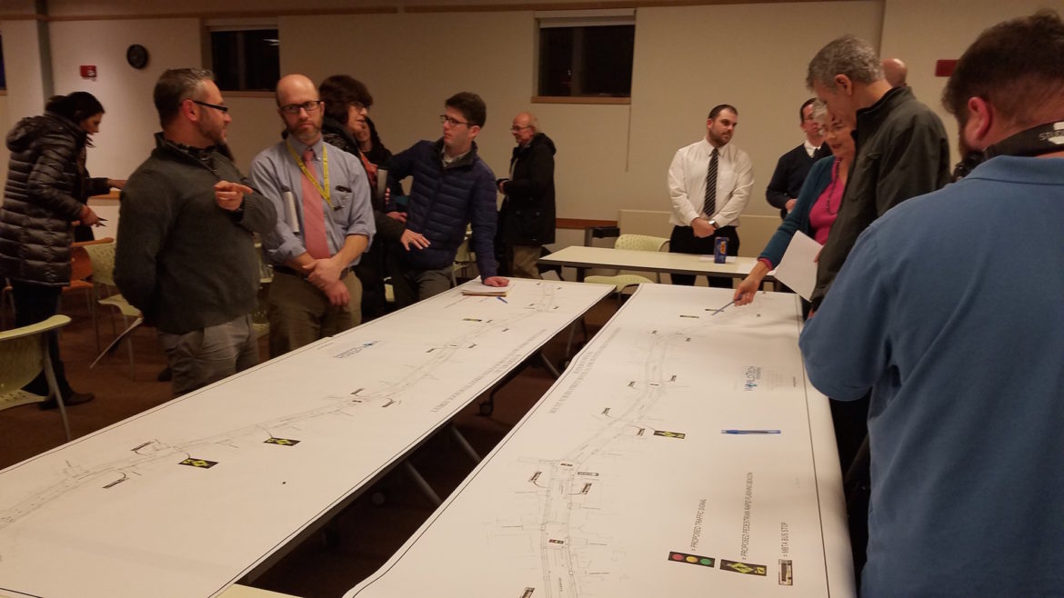
Residents and town staff look at look at drawings of plans to change Mt. Auburn Street from Watertown Square to School Street.
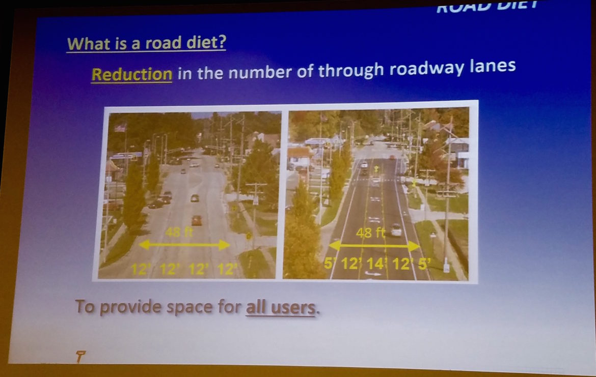
The town’s plans to renovate Mt. Auburn Street include a “Road Diet” where the roadway will be reduced to one lane each way for most of its length, and bike lanes will be added, along with some new traffic lights.
Plans were presented at the Watertown Library on Thursday night at a meeting where the Department of Public Works sought input from the public. The residents at the meeting had a mixed reaction to the ideas for changing the stretch of Mt. Auburn Street between Watertown Square and School Street.
Many did not think that reducing the lanes of traffic from two to one would work, fearing it would lead to traffic backups. Traffic Engineer Mike Pompili from WorldTech – the town’s design consultant – said that adding left turn lanes at major intersections will allow the traffic to move smoothly.
“Common sense is reducing from four lanes to two reduces capacity,” Pompili said. “If you are stuck behind someone waiting to go left, now you have to get around to the right lane. It creates friction with the right lane and increases the risk of side swipe accidents.”
Charlie Breitrose
An illustration of what happens to a street that undergoes a “road diet.”
Bicycle Lanes
The explanation did not convince some at the meeting, and many questioned why bike lanes were replacing lanes of traffic.
“Bicycles have as much right tot he road as motor vehicles,” said Public Works Superintendent Gerry Mee.
He added that any project that receives Federal funding must accommodate multiple modes of transportation, including not only motor vehicles but bicycles, pedestrians and public transportation.
The project will receive Federal money doled out by the state’s Transportation Improvement Program (TIP). It was ranked third in the state by the Boston Metropolitan Planning Organization, after the Needham Street/Highland Avenue area in Newton and Needham, and Ferry Street in Everett.
Members of the Watertown Bicycle and Pedestrian Commission said instead of a bike lane next to traffic they prefer a cycle track – a bike path separated from moving or parked vehicles by a curb.
Bicycle and Pedestrian Commissioner Sam Scoppettone said that he attended a Complete Streets training recently and learned that while only 7 percent of people find an on-street bike lane safe, 60 percent find a separate bike lane safe.
Others pushed for a dedicated late for buses and bicycles.
Mee said there is not enough space to have a separate bus and bike lane and parking.
New Lights, Turning Lanes & Transit
A new traffic light is planned for Boylston Street to allow traffic coming from Hosmer School to move more smoothly. Left turn lanes are planned in many spots, including at from Mt. Auburn Street to School Street and from School Street turning onto Mt. Auburn.
A left turn arrow is planned for people turning from Mt. Auburn Street onto Common Street.
Designers are looking at making Parker Street, which heads south off Mt. Auburn near Common Street, into a one-way heading away from Mt. Auburn Street. Few people turn from Parker onto Mt. Auburn Street, and removing that from the light sequence at Mt. Auburn and Common Street would speed up traffic, said Rick Benevento, President of WorldTech. Parker would also have more parking for businesses in the area.
The traffic lights will be designed to allow buses to have priority by keeping the light green when a bus approaches. The plan also includes spots for bus stops allowing buses to pull over so they do not block traffic, Benevento said.
Not Like Trapelo Road/Belmont Street
Several residents said they do not want Mt. Auburn Street’s renovation to turn out like the Trapelo Road/Belmont Street project.
“On Belmont Street there all these traffic islands were installed, but this has painted lines so if it doesn’t work out it can be rearranged,” said resident Russ Arico.
Town Councilor Angeline Kounelis said she can no longer get make a left onto Belmont Street after 3:30 p.m. because of the traffic back up.
“There are major issues,” Kounelis said. “I know we need to accommodate all, but we have to be sensitive to how we accomplish that.”
The meeting is just one step toward approving the project. Mee said this was a 3,000-foot view, and there will be more meetings to look at details such as the design of bus stops, landscaping and other things before the plan is approved.
Benevento said it could take five years before construction starts.
It looks to me as if the new “progressive” types who have moved into Watertown and got some of their ilk elected feel they must do something – anything – to put their stamp on the town even if it slows traffic.
Are we sure that emergency vehicles can get through when needed? I’m not so sure.
As for bicycles: They’re a menace and don’t belong on a busy main street such as Mt. Auburn. Ask most drivers, and they’ll tell you that.
As mentioned in the article the bike lanes ando pedestrian improvementso are a requirement if you get federal dollars. I think the DPW hopes getting bikes into their own lane will get them out of the way of traffic.
The requirement is that the road is accessible to all modes of transportation, which is already is – at the meeting the Watertown Bicycle and Pedestrian Commission noted that Mt. Auburn/Rt. 16 has a higher volume of cyclists than comparable roads/state routes in the area. There are already sidewalks and crosswalks as well, so nothing in the current design is preventing bikes or pedestrians from using this road. Even Gerry Mee noted that instead of bike lanes, Watertown could opt to have Share the Road signage, etc. that meet the Federal funding requirement. This seems like a much better option at this juncture, knowing what we already know about people’s habits (i.e. a significant number of motorists are NOT going to take up riding a bike – and definitely not during the 5+ months of the year that weather here is not ideal for biking – just because there is a designated bike lane) and the impacts that adding bike lanes in other areas have had. The fact that even the Watertown Bicycle and Pedestrian Commission had harsh criticisms about the bike lane as illustrated in the current design should absolutely cause DPW to rethink this design plan. They said at the meeting that they want to hear from the residents – and I surely hope that they listen and take our concerns seriously.
Believe me, “share the road” signs will not do much good on Mt. Auburn Street. Mt. Auburn is treacherous for bicycles. I avoid it as much as possible when I ride. Too many curves and too many motorists who speed, pass on the right, etc. It is a weak link in Watertown’s biking network.
Something needs to be done and we should not wait for the first bicycle accident fatality to do it.
Excuse me sir, but I happen to ride a bicycle and I take exception to your statement. In fact, you should be aware that Massachusetts law gives bicycles equal access to the roads, excepting restricted access highways.
Those who are arguing for better bicycle accommodations on the roadways are simply trying to make things safer for everyone. The use of bicycles is increasing. For many reasons, that is a good thing, including a reduction in traffic (or a slowing in the rate of increase, at least). I might also remind you that many who ride bicycles are children, who deserve our best efforts to keep them safe.
You can think whatever you want to think, but you cannot reverse the passage of time. We must respond to the challenges that prevail at the present, for return to the past is impossible.
Of course bikes belong in the planning. And of course cyclist must be safe. Cycle tracks are THE only solution. I cycle commute to work in Boston every day year round and will not ride on Trapelo/Belmont since the redesign. It’s unsafe. In some places the lanes press up against parked cars, in some places there are no bike lanes. It’s a disgrace. Let’s not repeat that disaster. Let’s build a safe road the accommodates everyone’s needs.
Look at how they screwed up arsenal street. Taking a left at the VIP auto center or at the entrance of the new apartment complex now leads to massive backups during rush hour. The street is so narrow at points that if both sides have parked cars a bus or large truck has to go over the yellow line. I had to stop once to let a bus pass! They really screwed things up.
I think a road diet is an excellent plan! It will make the street safer and easier to use for everyone, including drivers.
Currently, bicycles must share a travel lane with cars, which is stressful for both bicyclists and drivers. Pedestrians have a difficult time crossing the street because of the multiple lanes. And turning left as a driver can be difficult because you have to cross two lanes and end up creating dangerous weaving around you while you wait.
Re emergency vehicles, a road diet is actually better than multiple travel lanes. When traffic is heavy, bike lanes act as a space for cars to pull over and get out of the way of emergency vehicles.
Just WHY exactly is this project needed in the first place?
What is its purpose, whom does it serve, whom does it serve BEST?
Yes, when a community accepts state and federal highway funds for a particular project, its required that bike lanes and other accommodations be included in the plan.
But again… WHY even make ANY changes to Mt. Auburn St. to begin with?
What’s ‘broke’ about it, and if nothing is ‘broke’ why fix it?
This is just going to create unnecessary and unimaginable inconveniences and headaches for residents, commuters and business’s alike, and get nothing in return.
If that’s not reason enough to speak out and oppose this boondoggle, think of the problems it’s going to create while under construction?
According to the planners, engineers and developers present at the meeting, they themselves have no idea how long this undertaking could go on.
If they say it could take a year, we can be guaranteed it’s going to take 2 years or more/longer.
This whole scheme is nothing more than an appeasement to the small segment, ‘moving ahead into the 21st Century’ daydreamers mentality..
Anyone with any common sense, whom has lived in this community for any length of time, should oppose it.
The purpose is to make the street safer and more accessible for everyone. Whether you walk, bike, or drive, the new design will make it easier for you.
I highly doubt the new design will make it “easier” for the majority of us. If that was the case, there wouldn’t have been so many upset people and frustration at the meeting. Rather, this design plan will make it harder for everyone, so we’ll all equally be unhappy. I too question the primary objective of this new design. Mt. Auburn is a State Route – it will never be a “community road” – so let’s not try to pretend that it will be. With the going down to one lane each way, no one on the design team has talked about a massive problem with having one lane each way, and a leading cause of road rage – getting stuck behind a motorist who wants to drive slower than the speed limit/average speed of other motorists. Reducing the number of lanes is NEVER a good plan, no matter how you try to spin it.
People are upset because they are skeptical. I understand their skepticism, but just because they are upset doesn’t mean we shouldn’t do anything. Your statement that “Reducing the number of lanes is NEVER a good plan, no matter how you try to spin it.” is simply untrue. There are many examples from MA and from around the US and the world where reducing the number of travel lanes has resulted in a street that worked better for everyone. Refusing to recognize that does not make it untrue.
The safety concerns are being overblown by a certain few whom only have their self serving conveniences in mind.
Given the volume of traffic on any given weekday, (2010 study: Route 16, east of Common Street 23,379 per day), the number of bicyclists
and pedestrian incidents, is not horrifying or dangerously unsafe… far from it.
in 2012, there were 426 reported crashes/incidents total in Watertown.
22 involved cyclists and 24 involved pedestrians.
Mt Auburn St. accounted for 53 reported crashes/incidents, involving 4 cyclists and 4 pedestrians (6 if parking lots are included)
In 2013, there were 376 reported crashes/incidents total.
10 involved cyclists, and 23 involved pedestrians.
Mt Auburn St. accounted for 54 reported crashes/incidents, involving 2 cyclists and 3 pedestrians.
In 2014, there were 355 reported crashes/incidents total.
13 involved cyclists and 7 involved pedestrians.
Mt Auburn St. accounted for 51 reported crashes/incidents, involving 1 cyclist and 2 pedestrians.
(Source: Mass DoT Crash Portal)
One of the WorldTech speakers emphasized that by implementing this plan, that it would be safer for drivers as it would eliminate “sideswipes”
from vehicles caught behind a driver turning left, and attempting to merge right into passing traffic.
That too is an overblown situation to the extent of being nearly nonexistent.
In that 3 year period, there was a total of 15 reported “sideswipes”on Mt. Auburn St, and 90% of those involved parked cars,
of the remaining 10%, there were several at Mt. Auburn and Main St., which can be dangerous and traffic nightmare at any given
time or day of the week.
Some would say that even one incident is unacceptable, but where is the, acceptability of reasonable safety margins to be drawn
and not overly burden residents, commuters, taxpayers with unobtainable goals; that is zero auto, cyclist, pedestrian accidents?
The safety concerns that are being expressed, does NOT justify the response.
“More accessible for everyone”? Then why are buses being given priority to control the timing of traffic lights at intersections?
Entering Mt. Auburn St from certain intersecting streets can be frustrating enough (Bigelow Ave for example), because of the timing
of the lights. Enabling bus drivers to take control of the lights, increase the time the light turns green, or change to green at
their leisure, will increase the wait time for those coming off the side streets.
How is that “more accessible for everyone”. If there’s a burden or inconvenience, shouldn’t that be shared as well?
In the end, I guess none of this really matters, because despite any objections, this will be rammed down our throats by the powers that be no matter what..
Right now, bus riders are at a disadvantage compared to drivers. Giving buses priority at traffic signals would help to equalize the situation. Riding the bus is already much slower than driving, but it’s something we want to encourage more people to do, since reducing traffic congestion benefits everyone. If a bus with 50 people in it approach an intersection from one direction, and a few cars with 1 or 2 people in them approach from the other direction, it makes perfect sense to me that the bus should go first!
Many asked about going from 1-2 lanes and the engineers stated that the study showed that the traffic would flow(and with an increase of 10%). I’m still not convinced and it was asked if the studies were available to public. They said they were not currently and would not until they were finished. Not sure when that would be. If we do go to one lane, then I would actually want to make it a 21st century road by having a protected bike lane. This means having one side of the road with traffic/parked cars/small buffer(for doors) then a bike lane for two ways/curb. This is the only way to increase biking(as studies shows that the bike lanes next to the road are not safe or even perceived as safe). The buses also need to use this space for pull outs so cars don’t back up. One thing I am concerned about is the backup at Mt Auburn and Irving st area as a) it goes from 2 to one lane after Common St b) the increase traffic from multiple new development from Arsenal/Irving st. I would like to know what all our intersection ratings are(D, E…) and where we are taking them for the next 20years?