
Watertown officials have been working on not just preparing to react to but also to reduce the impact of natural disasters that could befall the town.
Watertown created a Hazard Mitigation Plan in 2012, and not is in the process of updating it. As part of that, the town will see how they can try to prevent injury, deaths and damage from events such as floods, high winds, winter storms, brush fires, earthquakes, extreme temperatures, and droughts.
The town is working with Martin Pillsbury, from the Metropolitan Area Planning Council, to update the plan.
“We are looking at what preventative action you have now and find out about gaps and see what we can do in the future,” Pillsbury said during a presentation to the Town Council last week.
Types of Hazards, Frequency
The most severe of these events could cause major damage and cost millions of dollars.
An analysis by FEMA estimates property damage, a major flood could cause $45.6 million to $69.1 million in damages in Watertown. Major hurricanes could also inflict big damage. A 100-year hurricane (one which has a one in 100 chance of happening any year) is estimated to cause $24.8 million in damage, and the number jumps to $112.5 million for a 500-year hurricane. The biggest damage could come from earthquakes. A magnitude 5 earthquake could cause $891 million while a magnitude 7 earthquake (the 1989 earthquake near San Francisco was 6.9) would do as much as $5.0 billion damage.
High frequency events — more than once every five years, or greater than 20 percent chance each year — include thunderstorms, winter storms, and nor’easter storms. Watertown is at medium risk (2-20 percent chance per year) for flooding, extreme temperatures, hurricanes/tropical storms, and ice storms (including hail storms).
Low risk disasters (1-2 percent chance per year) include dam failures, tornadoes, landslides, brushfires and drought. Earthquakes are a very low risk event, less than one percent a year.
The most severe damage would be expected from a dam failure. This would be classified as extensive damage, which means, the plan says, widespread major property damage, major public infrastructure damage (up to several days for repairs); essential services are interrupted from several hours to several days; many injuries and/or fatalities.
Disasters with serious damage (Scattered major property damage, some minor infrastructure damage, essential services are briefly interrupted, and some injuries and/or fatalities) would be flooding, hurricanes/tropical storms, and earthquakes. Others would be expected to have minor damage.
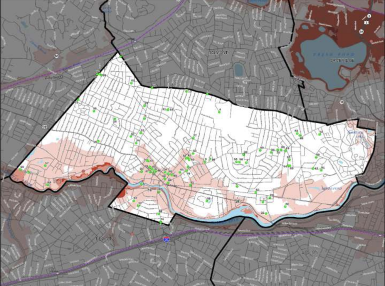
The draft Hazard Mitigation Plan identifies places where these events could have the most impact, as well as 82 critical facilities in Town.
Flooding
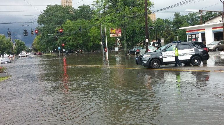
Being on the Charles River, flooding is one of the biggest concerns for Watertown. One of the goals of the plan is to: Identify and seek funding for measures to mitigate or eliminate each known significant flood hazard area.
A pair of storms in 2010 caused the Charles to overflow in parts of Watertown, and damaged the Dock in Watertown Square, carrying the platform downriver.
The plan points to six places were flooding has caused damage in the past:
- flooding along the Charles River, particularly above the Watertown Dam
- basement flooding at Cunniff Elementary School
- basement flooding at Watertown High School
- basement flooding at the new Police Station
- basement flooding of homes on Rutland Street
- flooding in the area of Arlington and Keith Streets after a series of three storms
Councilor Angeline Kounelis asked why the area of Laurel Street, where flood waters came up to the front doors of homes during a heavy rain from a storm that also caused a tornado in Revere in 2014.
Public Works Superintendent Gerald Mee said that flooding was more due to problems with storm drains on the surface, not underground, and that efforts have been made to prevent the flooding from reoccurring.
Dam Failures
Pillsbury said the Town could also be severely impacted by a dam failure, whether it is the Watertown Dam, or others upstream in other communities.
“They are all in good shape, but should they break, we look at all the very worst case scenarios,” Pillsbury said.
The dams which, should they fail, could cause major problems in Watertown include the Watertown Dam, which is owned by the Department of Conservation and Recreation.
Others, however are outside Watertown, and may not even be on the Charles. One is the Cambridge Reservoir on the Hobbs Brook in Waltham, which is owned by the City of Cambridge, another is the Weston Reservoir, jointly run by the DCR and MWRA. There are also several dams on the Seaverns Brook, which runs through Weston. Those dams are managed by the DCR and MWRA. Even the Stony Brook Reservoir, located in Norfolk, which is also part of the City of Cambridge water system.
Earthquakes
There have not been any earthquakes of magnitude 7 in or near Massachusetts in the historic record. There have been several between magnitude 4 and 6 dating back to Colonial time through recent years, including a magnitude 6 off Cape Ann in 1755 and a magnitude 4.5 on Nantucket in 2012. One measuring 2.3 magnitude centered in Boston was recorded in 1974, according to info in the plan.
Extreme Temperatures
While extreme temperatures are a medium frequency event now, Pillsbury said the recent Climate Projections for the 21st century show that Massachusetts and Watertown will likely mean more high heat days.
“Now the average year has 10 to 15 days over 90 degrees, but by late-Century it will be 30 to 40 days,” Pillsbury said. “It will feel more like the Carolinas than New England.”
Next Steps
Town officials are collecting input on the Hazard Mitigation Plan. Then it will be sent to FEMA and MEMA (Massachusetts Emergency Management Agency) to review and approve.
Once the plan is approved and adopted by the Town Council, the plan will go into effect. At that point, Watertown will also be eligible to apply for FEMA grants for projects to make the town more ready for hazards and natural disasters, Pillsbury said. The plan includes a list of proposed projects.
The plan is approved for five years, Pillsbury said, but beginning in the third year the Town will begin preparing for the next update.
See the draft Watertown Hazard Mitigation Plan here: https://www.watertown-ma.gov/DocumentCenter/View/26409/Watertown_MA_Draft_Plan_Update-2019-01-07.
Comments about the plan should be sent to Watertown Fire Chief Quinn at rquinn@fire.watertown-ma.gov, or call 617-972-6511, by January 18, 2019.
Comment submitted by Libby Shaw:
Happy to see that Watertown’s 2019 Hazard Mitigation Plan includes “Adopt Site Design regulations to increase shade tree plantings near buildings and increase trees used in parking areas and along public ways”.
Shade trees can be a lifesaver in times of extreme temperatures.