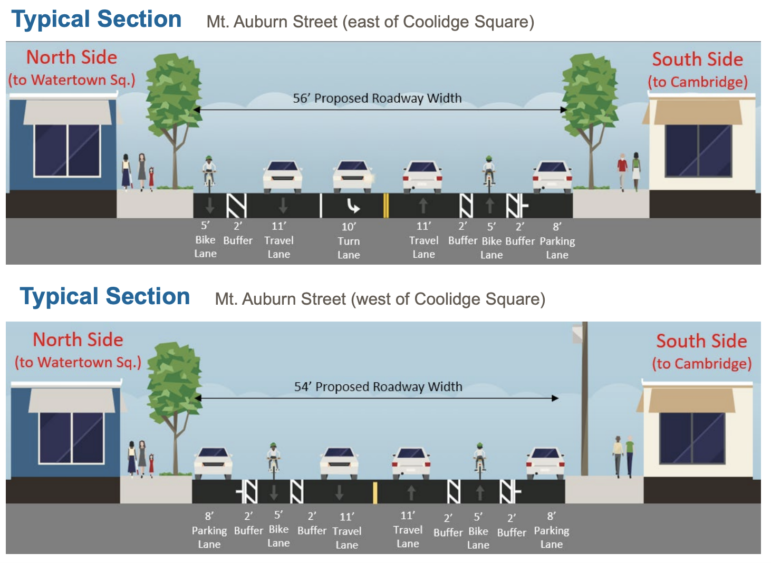
MassDOT Cross sections of Mt. Auburn Street with the “road diet” that removes one lane of traffic each way and ads turn lanes and bike lanes.
The redesign of one of Watertown’s major roadways will include some significant changes to the look of the road, as well as improvements that state officials said would improve the road for motorists, transit users, bicyclists and pedestrians.
The repaving and improvement of Mt. Auburn Street has been discussed for many years and officially got started by Watertown officials in 2009. Studies of the street and public workshops took place between 2010 and 2016. In 2016, it became a “Complete Streets” project, which aims to give access to all users. This also includes public transportation, bicyclists and pedestrians.
The project will cost an estimated $24 million, said Project Manager David Shedd from the Massachusetts Department of Transportation (MassDOT). It will be fully paid for by federal and state transportation funding, Shedd said: 80 percent from the Federal Highway Administration and 20 percent from MassDOT.
The 25 percent design was presented during a meeting hosted by MassDOT on Nov. 4.
One of the goals is to make Mt. Auburn Street a local road again, said Kris Surrette, project engineer with design consultants from WorldTech Engineering.
“Mt. Auburn Street is a municipal local road and we want to make it a local road again, not a cut through to get from Rte. 2 to the Mass. Pike or from Watertown to Cambridge,” Surrette said.
Rick Benevento, president of WorldTech Engineering (the design consultant) said the last time Mt. Auburn Street had a significant redesign was in the 1980s, when the goal was moving cars. This redesign will be a “Complete Streets” project.
“It is designed around not only cars, but pedestrians, cyclists and transit. All that has to be part of the design and there has to be a balance,” Benevento said.
The plans include the “Road Diet” discussed at previous meetings, which would reduce the travel lanes from two to one for most of the length of the roadway. Turn lanes would be added at major intersections to remove vehicles waiting to turn from the flow of traffic, Surrette said.
“When someone is looking to turn (now) you are effectively blocking that traffic,” Surrette said. “By having a road diet, with a dedicated through lane and turn lanes, it creates space — you are getting that turning vehicle out of that traffic.”
The two lanes each way configuration will remain from Watertown Square to Common Street.
New traffic signal technology will help traffic flow better, he added.
“It has been 30-40 years since the street was last reconstructed. Signal technologies have advanced significantly,” Surrette said. “They coordinate with each other and get a sense of traffic. The leap in technology will provide operational benefits at those intersections.”
Additions include buffered bike lanes along some sections of Mt. Auburn Street. These would have a two-foot painted buffer between the bike lane and the travel lane (and another between the bike lane and street parking, where applicable). Some stretches will have shared bike and vehicle lanes.
To improve bus flow, queue jump lanes will be added at some intersections, Surrette said, and there will be bus pull outs at some stops. Bus shelters will be added at stops with significant numbers of riders. Designers will be meeting with the MBTA to determine which ones will get shelters, Surrette said.
Four bus stops have been changed since the designs were last presented to the public, with two going back to where they are presently.
Boylston Street eastbound will be moved from the Southwest corner of Boylston and Mt. Auburn to a spot along the Hosmer School fence.
Adams Avenue westbound will move closer to Richards Road. The new location is beyond the crosswalk, which will have rapid flashing beacons and has a crossing guard during the school day.
MassDOT
Amherst Road westbound and Adams Street eastbound had been slated to be moved, but will remain in their current location.
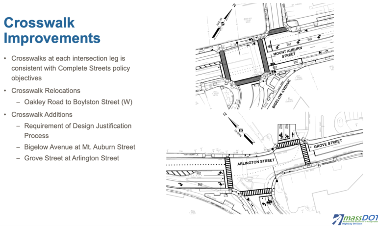
One crosswalk will be moved from its current location (Oakley Road that runs to a spot in the middle of the Hosmer School fence) to just west of Boylston Street. Surrette said this is a more expected location for motorists so it will be safer.
Two new crosswalks will be added. One on the western side of the Bigelow Avenue/Mt. Auburn Street intersection (near the Deluxe Town Diner). Another will be added on Grove Street at Arlington Street, near the driveway to the former Tufts Health Care building.
At School Street intersection, the sidewalks will be pushed out to decrease the width of the roadway that pedestrians must cross.
The Mt. Auburn Street designs must be completed by the spring 2023 to qualify for the Federal funds, Shedd said. Advertising for contractors will take place in summer 2023, with construction expected to begin in the fall of 2023, Shedd said.
Before work can start, utilities will do any upgrades to their infrastructure under the roadway. National Grid will replace gas lines with larger-width pipes along the length of the street, Surrette said, and the MWRA will replace a water main with a 20-inch pipe from Irving Street to Russell Avenue.
During the reconstruction, the wires for the MTBA’s electric buses (a.k.a. trackless trolleys) will be removed and put back after the project is finished.
More public meetings will be held, included when the 75 percent design is complete, Surrette said.
See more information at the project website, www.mountauburnstreet.com.
Comments about the project will be accepted until Nov. 19, 2021. Formal comments submitted to MassDOT will become part of the hearing / public record.
Formal comments should be submitted through MassDOT with the following contact information: By mail: Carrie Lavallee, PE Acting Chief Engineer, MassDOT 10 Park Plaza, Suite 6340 Boston, MA 02116 Attn. Project Management, Project No. 607777; By email: MassDOTProjectManagement@dot.state.ma.us -Use Subject: MassDOT Project No. 607777. You are welcome to copy the town through the project email – team@MountAuburnStreet.com
EXCERPT:
One of the goals is to make Mt. Auburn Street a local road again, said Kris Surrette, project engineer with design consultants from WorldTech Engineering. “Mt. Auburn Street is a municipal local road and we want to make it a local road again, not a cut through to get from Rte. 2 to the Mass. Pike or from Watertown to Cambridge,” Surrette said.
————————————-
Oh, so, Watertown wants OTHER nearby towns to accommodate these cars and increase the traffic in THEIR towns.
I think we understand such selfishness and disregard for others.
Notice that a “municipal local road” is being called for for Mt. Auburn Street while the STATE and MASS DOT pays for it.
How nice to want something for yourself and get others to pay for it.
So nice to see that even more additions to our roads will be made for the dozen people who actually ride a bike in Watertown, and when you do see many of them, they are on the sidewalks anyway. I wonder when the phrase “road diet” will be added to Webster’s Dictionary so the 99% of us who are laughing at it’s addition can truly comprehend it’s definition?
Reminder one comment per story unless you sign your whole name.
This “brilliant” master plan is easily the most foolish, wasteful and shameful use of public infrastructure I have ever witnessed or experienced in my 18 years of living in this community, or anywhere else for that matter. And for what? To appease and placate 2%-3% of road users. As if the cycling community hasn’t already had enough of a harmful/negative effect on Watertown and surrounding areas, they’re still not happy with this generous gift the state and town is offering them. It wasn’t enough that they whined and pleaded to get Lower Greenough Blvd closed off for their own selfish reasons at the expense of others, now they want to implore the state and Town Council to change the current plan to include separated bike lanes with flex posts so the transition between Watertown to Cambridge is easier… there’s no pleasing these people.
I like the occasional bicycle ride but modifying infrastructure to accommodate less than 1% of vehicle traffic in a state where bicycling is comfortable <6 months of the year and bike theft is almost a recreational activity is the definition of poor planning.
Another step closer to being just like Cambridge, all we need now is a MAYOR.
Watertown has been a city for over 40 years. Having a mayor OR a manager is what makes it so. What are you so afraid of? Were you hit by a bicycle?
I emailed the contact my feedback: (which I did years ago too): I am puzzled as to the goals of this project? If the goal is to get the most folks from Watertown into Cambridge/T in AM as possible and safely/environmentally than why not keep 4 lanes with a part-time dedicated bus/bike lane either always or in AM 6-9 and PM (West) from 4-7pm? If Full time dedicated then possibly add some of the dividers for a fully dedicated lane so that cars can not go into that lane(as they do now on the bus lane only portions and normally are speeding as they know they are not suppose to be there(bikers beware it is actually more dangerous!).
I drive on this road daily(during peak hours) and rarely am I caught behind someone turning left other than on School St at the light(still brief).
What I do find is a line of cars on Arsenal st(in PM peak) after it turns into 1 lane from School St all the way up to the Square(unsure how this is helpful with traffic flow) though I do love the protected bike lane on the sidewalk.
I do agree that cross walks should be made safer although I would still emphasize the bus lane/bike lane over all other designs as the biggest bang for the buck(getting people to and from, leaving more lanes during off hours for cars, protecting the bikers with dedicated bus/bike lane by having the lanes with protected lane departures if that lane was dedicated 24/7 (other than bus entries/exits).
I’m also baffled at the statement around municipal road vs local road and cut through for Rt2 to Mass Pike or Watertown to Cambridge. How else are folks suppose to get to Cambridge other than Mt Auburn! (Belmont turns into MT Auburn ) otherwise you can turn to (away from Cambridge somewhat)Arsenal then Nonantum to get to Cambridge/Brighton(which was made into 1 lane too). Confused again as the the critical thinking here.
What are the goals of the road diet other than making it one lane, an unprotected bike lane, better pedestrian cross(agree, this is needed at many spots) and more traffic?(especially given the $$ involved).
Scratching my head…