When work finishes on one of Watertown’s major arteries, the street will have fewer lanes in some places, protected bike lanes, and landscaped areas for people to gather.
Mt. Auburn Street will receive a major facelift, and be redesigned in some places, during the project that will impact almost the entire length of the artery that runs from Watertown Square to the Cambridge line.
The City submitted the 100 percent designs for the Mt. Auburn St. in May, and in September the project will be advertised to seek contractors and subcontractors. Details of the project were presented at an open house at Perkins School for the Blind in June.
Since the plans were last presented, designers have added truck loading and delivery areas in Coolidge Square, removed a traffic light, and added a bit more parking in commercial areas.
While the project has not officially started, much construction will take place before work on the project begins. The first step was deactivating the catenary lines (the electrical wires) for the MBTA buses on Mt. Auburn Street. Other pre-project work includes replacement of natural gas lines by National Grid, and MWRA water main replacement on the roadway from Russell Avenue to Irving Street.
Roadways
One of the most discussed aspects of the project is the “road diet,” where parts of Mt. Auburn Street will be reduced from two travel lanes each way to one, with left turn lanes at larger intersections. The road diet begins east of Common Street because west of that area the intersections and traffic volume does not support the diet, said Kris Surrette of Tighe & Bond, the project designers.
Some traffic signals will be altered during the project.
The light at Mt. Auburn and Common streets will no longer have the same traffic pattern, Surrette said.
“Parker Street will no longer be part of the Common Street signal,” he said. “We removed this intersection leg from the signal based on feedback we received from the DOT, MBTA, and the overall intersection delay that this leg of the intersection created as part of the traffic signal.”
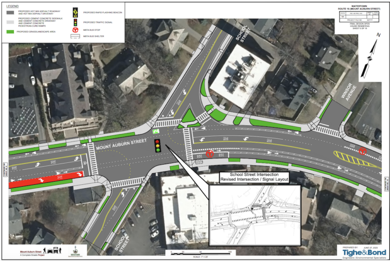
One planned new signal was dropped from the plans.
“During the 25 percent design we showed a traffic signal at this location. Moving forward we have proposed an overhead flashing beacon,” Surrette said. “Additional traffic counts and analysis were taken at this location and a traffic signal was not warranted.”
Currently, businesses on Mt. Auburn in the East End that get items delivered by trucks use one of the two lanes to unload deliveries. With the road diet, many business owners worried about how they would receive these deliveries.
“Based on our meeting with business owners in the Coolidge Square business district we have implemented loading and delivery zones at select locations within Coolidge Square,” Surrette said.
The loading zones are located in four spots along the westbound side of Mt. Auburn Street, as well as just off the street on Dexter Avenue, Upland Road, Melendy Avenue, Lloyd Road, Elton Avenue, and Kimball Road.
The intersection at Elton Avenue has been reconfigured, and a parking space has been gained on Mt. Auburn St., Surrette said.
Bike Lanes
The renovation is a Complete Streets project where the corridor is designed not only looking at motor vehicles, but also public transportation, bicyclists, and pedestrians.
Bike lanes will be located on both sides of Mt. Auburn street between Common Street and the Cambridge line. Many stretches of Mt. Auburn Street will have buffered bicycle lanes, where the roadway will have markings between the auto traffic lane and the bike lane. In a few areas, there will be a double buffer, with markings also between parked cars and the bike lane.
Heading east from Common Street, there will be a double buffered bike lane on Mt. Auburn Street from Walnut Street to Boylston Street. In Coolidge Square, there will be a single buffer on the parking side of the bike lane. This stretches from Elton Avenue to Prentiss Street where a double buffered area starts and runs to Cottage Avenue. One the last block before the Cambridge line (at Belmont Street) the bike lane merges with the dedicated bus lane.
Westbound, there is a double buffered bike lane that starts a short distance from the Cambridge line and ends at Keenan Street. A single buffer on the traffic side of the bike lane begins at Upland Road, runs through the School Street intersection and ends at Garfield Street.
Bicycle parking will be located at multiple locations on commercial blocks, bus stops, gathering areas, and other locations, said Skyler Chick, a landscape architect with Shadley Associates.
Pedestrians
For pedestrians, there will be rapid flashing beacons at crosswalks on Mt. Auburn at Boylston Street (west side), Winthrop Street, Langdon Avenue, Adams Street and Dexter Avenue.
The crosswalk currently located at Oakley Road has been moved west to Boylston Street, where there will be an overhead flashing beacon to alert motorists that someone is crossing.
A crosswalk will be added at Mt. Auburn Street and Bigelow Avenue. Currently there are two crosswalks — one across Bigelow Avenue and one east of Bigelow — and a third will be added on from the sidewalk in front of Deluxe Town Diner crossing Mt. Auburn Street.
“We are required to provide a crosswalk at each leg of the intersection,” Surrette said.
Benches will be placed along the corridor to create resting points, Chick said. They will be located at bus stops when possible.
Gathering Areas
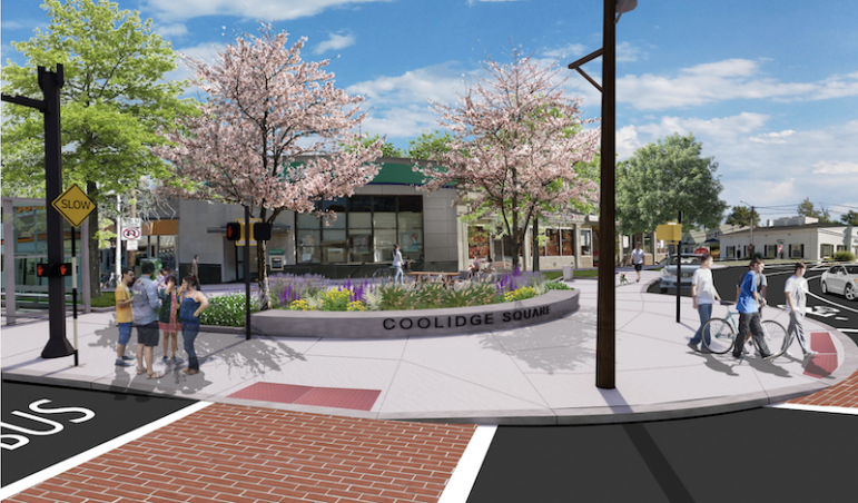
Several major intersections will be enhanced to create places for people to gather, and will include seating, bicycle parking, trash receptacles, and in some areas “gateway walls,” Chick said. These include the Mt. Auburn Street intersections at Boylston Street (east), Bigelow Avenue, as well as at the intersection of Arlington and Grove streets.
“At Bigelow and Mt. Auburn we have another area,” Chick said. “This is in the heart of Coolidge Square. At the corner facing the intersection we are proposing a long curved granite wall engraved with the words ‘Coolidge Square.'”
Another placemaking sign will be placed at the intersection of Arlington and Grove Street. The landscaped areas will follow Arlington Street as it curves away from Grove Street. Benches will be placed near a grassy area where there will be trees, shrubs and other plantings.
At Boylston Street, the sidewalk area will be expanded near the St. James Armenian Church, with benches shaded by trees, with other landscaping added.
The project includes adding trees and other plants along the length of Mt. Auburn Street.
“We want to enhance the existing tree canopy by infilling with new trees,” Chick said. “We also want to increase the diversity of tree species. Diversity in plant species is critical for the longevity of the landscaping.”
A variety of plants and trees species will be chosen to give the area seasonal interest with flowing trees and different colors during the fall. Also, plants and trees that help pollinators and wildlife will be selected, Chick said.
Bus Stops
Part of the Mt. Auburn Street redesign includes some changes to bus stops to improve bus operations.
“Several bus stops will be relocated,” Surrette said. “This is from feedback from abutters, from the City of Watertown, and also from the MBTA.”
The stops impacted are: Amherst Street westbound, Boylston Street (west) eastbound, and Adams Avenue eastbound.
See videos about the Mt. Auburn Street project and detailed drawings by clicking here.
Sounds like, intentional traffic jams
Does the plan include getting rid of the 7-11 in Coolidge Square? Now that would be an improvement!
More multi-family housing projects and reduced travel lanes. Makes perfect sense.
What about handicap parking? Mt.Auburn St. Coolidge Square, is terrible.
When we are trying to attract new businesses to Watertown, you want to destroy one that seems to serve a purpose to the community. If people didn’t want it, they wouldn’t go there.
I don’t go to that area of the city much due to the congestion and lack of adequate parking. With all these road changes, that will probably only serve to discourage me more from going there when it’s finished. I don’t ride a bike and many other older or disabled people don’t, and families with children need cars to shuttle them and all their gear to many different locations. I hope the businesses survive with all these changes. The small-business owners don’t always get the attention or respect that should be afforded them.
Joan…I live right around the corner from the 7-11. It’s a dump, an eyesore, and a haven at night for the rodent population. The franchisee of that store appears to care nothing of the neighborhood much less have any pride of ownership. If that store was located in Belmont, it would have been closed down years ago for all sorts of violations. There are good businesses that embrace the community and others that just make a buck, don’t be so naive.
“families with children need cars to shuttle them and all their gear to many different locations” — This statement is false. I have three small children and I travel around Watertown exclusively by bicycle with my kids. The people who assert that biking isn’t a viable method of transportation are always the same people who have never given it a try.
I’ll have to say, none of your kids play Hockey.
I went to many meetings about this project as the plan was coming together because I thought it would be a disaster. I still believe it will be and the progression of the project to where it is now just confirms my belief that the meetings were just for sh0w, as the decision to do this had already been made! For those of us living in the affected areas, it will be a nightmare! Only one lane on each side of such a busy street? It’s already not easy to turn from side streets onto Mt. Auburn! And those left-turn areas to turn off of Mt. Auburn do not occur at every intersecti0n. Do any of the people who advocated for this plan even live in this area?
I too followed this plan throughout the years and agree, this is basically the same plan from day 1. I asked what the goals of the plan were and did not really get much of an answer. From my perspective, goal1: some of the pedestrian walkways are dangerous, fix these to make them safer for crossing goal2: Is it a goal to get as many people from Watertown to Harvard SQ T? If so, just have a bus lane 6:30am-9am going East and 4:00-7pm going West and some better cross walks. Done. Goal3: if we have to have 1 lane can we at least have a protected bike lane as the current bus/bike lane is quite unsafe(cars zip by me on that lane to get by without getting caught all the time) ..we were told this could not be done due to the many driveways. Question4: How many people actually need to turn left to a side street(other than possibly School St) or Common(which will still be 2 lanes) other than folks that live up there? I’m still scratching my head with this one, other than some safer walkways(which could still be achieved with 2 lanes IMO) this doesn’t get more people in buses to their destination nor people in cars. For those on bikes, I love my bike but rarely use it to go down Mt Auburn St(unsafe on road and most months weather is not great(cold/snow, hot/humid). If the goal is to have more traffic, then I think they maybe spot on unfortunately.
Regarding your Question 4: There are plenty of people who live in the areas where thy have to turn left to a side street (I am one.) With one lane on each side of Mt. Auburn St., it will also be difficult for the residents to turn from the side streets onto Mt. Auburn; Even with the two lanes, I have to wait a long time for a break in the traffic to enter the street, but with one lane it will take even longer for a break since two lanes worth of cars will be backed up in one lane! And if everyone will have to used School St,. that street will back up pretty badly and it will take forever to get anywhere. It’s not a matter of wanting to rush everywhere, it’s a matter of making it to a doctor’s appt or to one’s job on time. Non-residents of these areas will need to take a left onto these streets when visiting residents there or going somewhere else via the street.
Marian,
I think we are both agreeing that keeping 2 lanes would be helpful for everyone(though better crosswalks needed). My point #4 was that of the % of cars that go down Mt Auburn there is a small % of those cars which actually turn left to some of the side streets. Your points are also true, there will be along line of cars(longer than now) due to the one lane. The problem is we are yelling into the void as this was the design from day 1 and I don’t know many folks in Watertown who like this idea, other than better cross walks.
I hope the “one lane” plan doesn’t have us saying “I told you so!” Still thinking of emergency vehicles, traffic back-up and headaches for those who live on Mt. Auburn and need to exit their driveways. I guess the snow plows can manage!
My safety concerns would involve the traffic lights, I hope they’re not like 40′ in the air like Belmont St, looking up for a driver waiting to go does not make it very safe for pedestrians crossing at the last minute nor a bike whether stationary or moving. Never mind the fiasco of Common St/Trapelo Rd. Cushing Square from Watertown to Belmont! One other concern was the moving of the crosswalk from Oakley to Boylston St, better to have more crosswalks than someone trying to cross without one. Safety first/second may be too late!
I’m not sure the two lanes from 4 will be that bad. N. Beacon St and Charles River Road went from 4 to 2 years ago and it actually resulted in traffic calming, not backups (sometimes it will back up when there is heavy traffic due to a redirect, but not for long.) The roads are a lot safer for everyone.
I hope this happens in Coolidge Sq too. Mt Auburn is a different animal I know. One of the problems will be people stopping in the road to pick up I’m sure. Would be nice if bicyclists were required to defer to pedestrians too. Those bike lanes will be a license to speed thru.
Reminder comments must be signed with your full name.