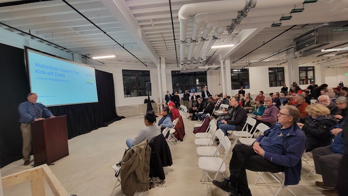
Hundreds of people packed a room to find out about plans for the future of Watertown Square. They saw a lot of transformations of downtowns around the United States and in other countries, but both City officials and members of the planning team gave a message that it is up to you, the public, to decide what Watertown’s center looks and feels like.
Many have been looking forward to the chance to improve how the Watertown Square intersection operates traffic-wise, and make it a destination for shoppers, diners and others, said City Council President Mark Sideris.
“This is an important time for us. This is an exciting time for us, as well, because we are talking about the transformation of Watertown Square,” he said. “It is a very busy place, as you all know, and these are the opportunities for everybody to weigh in as to what we are going to do.”
Improving Watertown Square was a high priority for people participating in the recent Comprehensive Plan update, said City Manager George Proakis. He has heard similar sentiments since arriving in August 2022 when he met with community members and the City Council.
Proakis listed some of the common feelings expressed to him: “It should be a better downtown for Watertown. It should be more of a destination. It’s a transportation mess. Businesses here, some of them are struggling. Why can’t we be more vibrant? Why can’t we be more like (fill in the blank) — it is always a different neighborhood. We should preserve history. We should have more housing.”
After the announcement of the Watertown Square planning effort, people have had new questions for Proakis.
“People ask me, what are the aspirations? What is the plan going to say? What are we going to do?” Proakis said.
He responds, “Basically, that is up to you.”
Tim Love, principal of Utile, reiterated that the designers are coming in with a blank slate.
“We have no idea what we are doing here,” Love said. “That is both a commitment to the kind of transparency and our open mindedness we have, but it is also a really hard problem, too.”
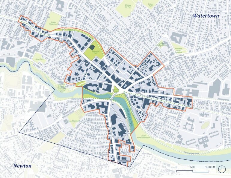
The picture will begin to take place over the next several weeks. The planning process began Tuesday with the public launch of the Watertown Square Area Plan. The event took place at the former Sasaki building on Pleasant Street, just outside the Square. Proakis stressed that the new plan will include areas well beyond the traffic intersection called Watertown Square, and reach down the major streets for several blocks (see the map below)
The process will continue with a series of Kitchen Table Conversations where residents will host several neighbors to provide input to the project planners about what they would like to see done in the Square. The conversations will be led by Watertown Community Conversations. (Sign up as a Kitchen Table Conversation (KTC) host by filling out this form by this Friday Oct. 20). Then there will be an intense, three-day planning charrette on Nov. 28-30, which will involve an interactive exercise between the consultant team and the public to “imagine alternative urban design scenarios for Watertown Square,” said Loren Rapport, the project manager from Utile.
While many focus on the traffic congestion in Watertown Square, the plan also includes making the area more inviting, a better place for businesses to operate, a place for public art, a place to just hang out. It also looks at housing for the area. Proakis said the timing of the Watertown Square Plan is designed so that the new vision can be captured in the City’s Zoning before the projects come forward to the Planning and Zoning Boards. The plan will also be designed to meet the requirements of the MBTA Communities Law, which calls for zoning areas in Watertown that will allow for 1,700 housing units to be built by-right, and therefore won’t have to go through a lengthy approval process. Watertown’s deadline for meeting the MBTA Law requirement is the end of 2024.
Utile has experience working with the MBTA Communities Law, having worked on the plans for the City of Newton, which has a deadline of the end of 2023.
A Walkable Square
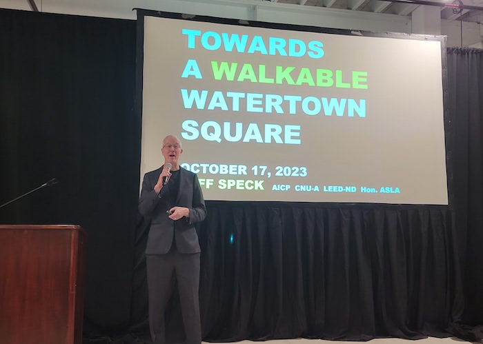
Much of the evening’s presentation was given by Jeff Speck, a “walkability guru” hired to work with the design consultants from Utile. Proakis said that he has learned some key things from Speck, with whom he teaches an urban planning workshop at Harvard each year, called The Walkable City.
“I was once told by a highly regarded walkability expert (Speck) when it comes to walkability, if you have one place to start it is best to start in your downtown because the square is the one area of the city which is meant to belong to everybody. If you live in the Square, in the East End, West End or Southside, it’s the defining heart of the city which all of us say we have some belonging to regardless of where else in Watertown we are.”
There are four areas that Speck said are key to making a place more walkable.
“The general theory of walkability asks the question here in America, in which driving is so cheap and so easy — it is heavily subsidized, under those circumstances when will people make the decision to walk and not drive,” Speck said. “And the answer is the walk needs to be as good as the drive, or better. And to do that it needs to do four things simultaneously: it needs to be useful, it needs to be safe, it needs to be comfortable, and it needs to be interesting.”
Many places in the U.S. have roads much wider than necessary, Speck said, including Watertown. Lanes of traffic only need to be 10 feet wide, but many in Watertown are 12 feet or more, including the major roadways such as Mt. Auburn Street and Arsenal Street. And more width leads to more speed, Speck said.
A key to making walks safer is to calm traffic. During the event, Speck showed the audience a video of the transformation of a traffic choked intersection in the small town of Poynton, England, into a calm, pedestrian friendly area by cutting lanes to one each direction, narrowing them and making the major intersection a “shared space.” The intersection, which looks like two circles pushed together, has no traffic lights, but with slower speeds drivers find their way across in an orderly fashion. See the video about the project below:
Adding protected bike lanes, either up at sidewalk level or behind a row of parked cars, would increase the number of cyclists, Speck said. In Brooklyn, a three lane road near Prospect Park was cut down to two, and a two-way bike way was added. Parking was moved off the curb on the other side of the bikeway.
“The number of cyclists tripled, sidewalk biking disappeared, speeding dropped precipitously, injury crashes were down 63 percent, and just as many cars are using this street as before,” Speck said.
Higher speeds can cut the number of cars moving through an intersection, Speck said, because cars travel farther apart at higher speeds. He added that backups are caused by not being able to get through an intersection, not because of the width of a lane, or number of lanes. He looked for ways to keep traffic flowing.
(A shorter version of Speck’s Walkability talk can be seen in this TED Talk (click here).)
Dan Driscoll, a Watertown resident and Director of Facilities at the Department of Conservation and Recreation (DCR), noted that Watertown has already seen reduction of lanes on Charles River Road, Nonantum Road and Greenough Boulevard. The projects, which he oversaw, led to increased park and recreation space.
Speck created the drawing of the “double roundabouts” in Watertown Square, which he presented during a Charles River Regional Chamber meeting in October 2022. The drawing, which he said he put together when he had “a spare hour,” shows roundabouts at the main intersection in Watertown Square, as well as where Pleasant Street hits Main Street. It also doubles the amount of green space on the Delta.
Jeff Speck
A concept for Watertown Square drawn up by city planner Jeff Speck, on the right, with an aerial photo of the area as it exists now. 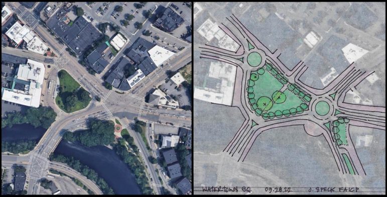
Some worried that such a plan would turn Watertown Square into the Fresh Pond area, with its large rotaries. Speck said that roundabouts are smaller and have a tighter turn than most rotaries seen in Massachusetts. They also have only one lane.
Others were reminded of the era when Watertown Square operated as a rotary, with traffic circling a smaller delta. Some recalled that as a traffic nightmare, while others liked it because it was more pedestrian friendly.
“When we had a rotary it was walkable,” said Marilyn Petitto Devaney. “You could cross the street.”
Speck added that the roundabouts would remove the complex system of lanes leading into the square, which often confuses drivers new to the area or who rarely drive through the intersection, including Speck, who lives in Brookline and grew up in Belmont.
Mohammad Tahmili, the owner of Tabrizi Bakery on Mt. Auburn Street (one of several eateries providing food for the event) said that he worries that cutting down lanes and adding bike lanes would remove much needed street parking. Most of his customers pull up for a few minutes to grab something and go. Also, deliveries are made by trucks stopping on Mt. Auburn Street.
That can be one of the biggest challenges, Speck said.
“The toughest nut to crack is the deliveries or pull over and grab something,” Speck said. “You can dedicate room for cars to stop and grab something and leave. A standing area, not parking.”
Speck told the audience not to get to focus on the double roundabout drawing, or the Poynton redesign.
“That’s not the plan. It is one of about 20 configurations we are contemplating,” Speck said. “I wouldn’t design anything like Fresh Pond.”
Find out more about the Watertown Square Plan at the project website (click here). Sign up for email updates on the project by clicking here.
See the Watertown Cable video of the Watertown Square Plan event by clicking here.
“Walkability” and more bike lanes. Watertown is, and always has been very walkable! As far as more bike lanes go, how many bicyclists does anyone actually see in a given day? Not that many, and if you do, half are on sidewalks endangering pedestrians.
Cyclists may be riding on the sidewalk because the adjacent roads are unsafe for them. Bike lanes provide a solution to that problem.
As to the safety threat to cyclists, I only need to point to the recent fatality in Silver Lake at the corner of Bridge and Watertown street.
Cyclists are vulnerable road users. Protecting them encourages more folks to ride. I see many cyclists here in Coolidge Square and few on the sidewalk.
Mount Auburn street is so terribly paved that it’s nearly-unusuable for cyclists throughout most of Watertown.
Sincerely,
A cyclist who sometimes rides on sidewalks.
Now what about the many cyclists that choose to ride on the sidewalks because they don’t like the conditions of the streets putting pedestrians in danger??
Many whom are walking with young children and pushing strollers. They take up the entire sidewalk which is wrong!
From what I see here in Coolidge Square, there aren’t many sidewalk riders and most of them are kids. As much as I don’t like it, I’d rather see them ride on the sidewalk rather than out on Mount Auburn Street, where their chances of serious injury or worse are very high. Let them live to see High School.
What I would like to see in Coolidge Square is some red light enforcement. Almost every light cycle there are multiple runners.
I’m somebody who runs 1 hour per day around Watertown and I don’t drive — I bike exclusively around Watertown. I think much of Watertown is walkable but Watertown Square is the glaring exception. Here are an incomplete list of some very obvious reasons why:
1. The slip lane from Main St onto Galen St encourages drivers to go fast and introduces a conflict point between drivers and pedestrians in order to convenience drivers.
2. The 2-lane turn from Galen onto Main St is truly awful. Cars run reds all the time and block the crosswalk. When we do get the walk sign, cars from Mt. Auburn turning onto Main St endanger pedestrians. I run across this crosswalk waving my arms in the air.
3. The intersection doesn’t meet ANY of Speck’s criteria for walkability: useful, safe, comfortable, interesting
4. Crossing North Beacon and Arsenal has many different small little cross walks that are hard to navigate. I saw somebody get hit by a car there once. I never got to find out if they were okay
5. It is over built. It is built for rush hour traffic which means that on off-peak hours people go too fast because the intersection invites you to go fast with the big wide open lanes. It’s safer at rush hour because of all the traffic keeping the cars slow.
Okay now onto your point about biking. “how many bicyclists does anyone actually see in a given day? Not that many”. Yes, do you know WHY that’s the case? because Watertown is NOT designed to be safe for cyclists. As somebody who literally bikes these streets every day I can 100% understand why anybody who’s at all risk averse would avoid biking in Watertown, ESPECIALLY Watertown Square. I’ve cut my teeth biking in the Boston area since 2008 and there are still some places I’m too afraid to go on a bike. Watertown Square is one of them.
It’s a little like saying “Why is nobody swimming in these shark infested waters? I guess people just don’t want to swim”.
Bottom line: Do we want more people biking? If so, we need to make the streets safe for cyclists. If you build it, they will come. This applies to all modes of transportation. If you build tons of car infrastructure don’t be surprised if what you get is lots of cars and traffic. If you build safe bike infrastructure, you’ll get more bikes.
Great points and well put.
I bike on the sidewalk because I’m 73 years old and because the bike lane on Main Street suddenly dies as it’s heading into the square.
Sounds like a good start. But if the MBTA can dictate housing policy, they better do their part and fix public transportation. An article here just the other day noted how miserably the bus routes serve the town. Other articles have noted the historic and cultural heritage of Watertown. Keep that in mind when reconsidering the Square. And trees! There seems to be a healthy budget for trees. Keep on plantin’.
I could not attend or Zoom due to work. Is there a recording of this somewhere? I don’t see up on the Watertown site nor on the WACTV site.
Yes, you can see it here http://vodwcatv.org/CablecastPublicSite/show/2830?site=1
Thanks so much!
I think this link is a better one http://vodwcatv.org/CablecastPublicSite/show/2824?site=3
Removing *any* parking is totally unnecessary. Quite honestly I’d feel less inclined to frequent business’s in the square if parking became am issue. I’m also curious what the speaker meant by “the number of cyclist tripled”. Did it go up from 1% to 3%, or was it from 10% to 30%? Did the numbers go up from 10 riders per day to 30/50/70 or more?
As far as having to comply with the MBTA Communities Law, hopefully at some point in the future either some of the communities affected by it will file a lawsuit to stop it, or if that’s not feasible, place it on a statewide referendum ballot to repeal the law.
Communities should not be forced to comply with mandates that they want no part of. Especially if that mandate will detrimentally affect the quality of life and character of their neighborhoods.
A 2021 article states that Prospect Park West now gets 350 bikers per HOUR at peak hours.
We really need to build for the transportation we want, not just cater to what we have now. Do we want more people biking? Then we need to build more bike infrastructure. Watertown’s bike infrastructure is severely lacking to the point where it deters people from biking. Nobody wants to ride in the door zone of parked cars while getting passed by an antsy F-150. I saw a car go 38mph down School St 2 days ago and pass a biker. That’s the state of biking on most streets right now. If anybody wonders why there’s so much sidewalk riding in Watertown, this is why. I don’t blame folks riding on the sidewalk. Cars have intimidated them off the streets.
Look at what’s happening in Cambridge. They’re aggressively building out bicycle infrastructure and they’re getting much higher ridership numbers! This is a big win. I recently ran through Inman Sq at rush hour and there were more bikes than cars! It was wonderful!
I looked at old satellite photos of Watertown Square (https://imgur.com/EqTzRee) and I counted how much parking was actually being used at the time these photos were taken. In every single instance there was way too much parking, under 50% utilization. Parking is massively space inefficient. In the image I linked, I blacked out all the parking lots and it looks like I blacked out most of the square!! All of that space to store about 360 cars? Seems a little much to me.
Also I’m all for adding a lot more housing to Watertown, I think it’ll be a positive change and I’m all for it. There’s a huge housing crisis right now, we should do our part to build more housing.
Mr. Fortin – You’re missing one key point about the MBTA Communities Law… It was necessary to pass a law at the state level precisely because cities and towns refuse to let others into their communities. For many decades, local residents have fabricated dozens of different excuses why no multi-family, multi-story housing should be built near where they live. What these NIMBYs fail to recognize is that they’re not the only stakeholders. Decisions must be made by considering 360 degree impact on ALL AFFECTED STAKEHOLDERS, including those who want to live here as well as local businesses who want more customers.
Having lived in the square when there were round a bouts and now, I can say with absolute certainty that traffic was much more efficient with the round a bouts! And, with walkers having the right of way there was less waiting to cross the street.
I would also invite the idea of pedestrian / bike fly-overs (or perhaps tunnels?) from the parking lot behind CVS to the delta (via the pass through next to CVS) and or along Beacon st. (perhaps next to the gas station at the intersection of Beacon and Arsenal St.) to the delta.
I’ve heard from a few folks who were around in the previous roundabout configuration and I’ve heard many good things. Thanks for this perspective!
However, overpasses or underpasses are extremely costly and provide a much worse experience for pedestrians and bikers. I’m somebody who regularly uses these kinds of infrastructure. Three that come to mind are the pedestrian bridges over Soldier’s Field Road, the Arthur Fiedler Footbridge, and the Frances Appleton Bridge at Charles/MGH. In the first two cases they’re inadequate for bike travel and quite annoying for pedestrians.
The Frances Appleton Bridge is decent but it requires a massive footprint and it cost $12.5 million dollars. For context, The whole Mt. Auburn St reconstruction will cost $30 million (if my memory serves)
Underpasses are depressing places to be and best only if they are short and can get decent daylight (like one under the Belmont commuter rail station which isn’t great but also isn’t horrible).
Could it work? Possibly. However I’m inclined to think of it as more of a costly last-resort.
Roundabouts, in my experience, have never seemed pedestrian friendly.
One of the most pedestrian friendly friendly places I have experienced is Las Ramblas in Barcelona, Spain. What a delight it would be to have such a place in Watertown Square: great for business and walking…. However, Main Street, even including the now existing sidewalks may not be wide enough???
I’ve never been to La Rambla, but I’ve seen videos. It’s a wonderful boulevard which emphasizes people over cars which is something we should be doing more of. La Rambla is approximately 100ft wide compared to Main St which is about 63ft (both estimates include sidewalks). We currently give about two thirds of the width of Main St to cars (and the 70 bus)
I think if Main St is going to become a destination we need to somehow get rid of a vast majority of the car traffic and the remaining car traffic needs to be slowed down to pedestrian speeds. Many streets are like this in Europe. Nobody wants to hang out on a street with nearly a constant stream of cars going by at all times. It’s loud, it’s polluted, and it’s a car-priority street.
Reducing travel lanes on Main St might be hard because the 70 bus goes down there so any attempts to increase frequency of that bus would mean it is getting stuck in ever worse car traffic. La Rambla also has the added advantage of having an underground subway going underneath it which is something I only wish we could have more of around here. Imagine if the Red Line could go from Central all the way down Western Ave and Arsenal St (along the current 70 bus route). I know somebody will probably chime in and say “it’s impossible and/or impractical” but I can still dream. A subway could reduce traffic and also justify reducing the car lanes and speeds quite a bit.
In short, I’m now depressed that we can’t have a beautiful boulevard like La Rambla due partially to poor transit and partially because of an unfortunate car culture that will surely fight against any attempts to reduce parking or travel lanes.
Before giving in to depression, know that Las Ramblas in Barcelona is a hugely crowded tourist magnet with lots of souvenir hawkers, people taking selfies and aggressive street performers (I’ve been there). Locals avoid it. Another model might be the Third St. Promenade in Santa Monica, CA…. lots of shops and restaurants on either side of a 3-block car-free street studded with public art. It’s a magnet for the community.
Before suggesting that people just give up their cars, let’s focus on creating a FUNCTIONAL public transportation system. That’s a good place to put our energy.