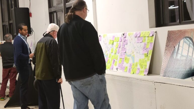
After an intense two days of gathering input from the public and looking at different ways to improve how Watertown Square works, the City of Watertown’s consultants presented two ideas that would significantly change traffic patterns in the intersection, but would not have a rotary.
The two main contenders for the new Watertown Square layout are known as “Four Corners” and “Mini Main Street.” Both ideas would significantly shrink the amount of space dedicated to roadways and would increase the size of the Delta and other green spaces, as well as provide parallel parking, wider sidewalks, bike accommodations, and easier bus connections, the consultants said Thursday night.
On Wednesday, urban designer Jeff Speck presented three drawings, the Four Corners, Mini Main Street and also one known as the Deltabout, where traffic would flow counter clockwise around the Delta. Residents at the meeting that night were split among the first two, but only one person liked the Deltabout, with others saying it isolated the Delta by putting traffic on all sides. Speck also said that he did not like any sort of roundabout or rotary at the main intersection for a couple reasons.
“(A roundabout) doesn’t feel static, it does not feel urban and walkable,” Speck said. “Also, we met with members of the sight impaired community, and blind people do not like roundabouts. I had never done that, walk around with that community and see it through their eyes, so to speak.”
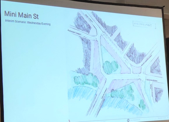
That left two options, Four Corners, below, and Mini Main Street, second down.
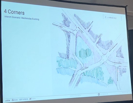
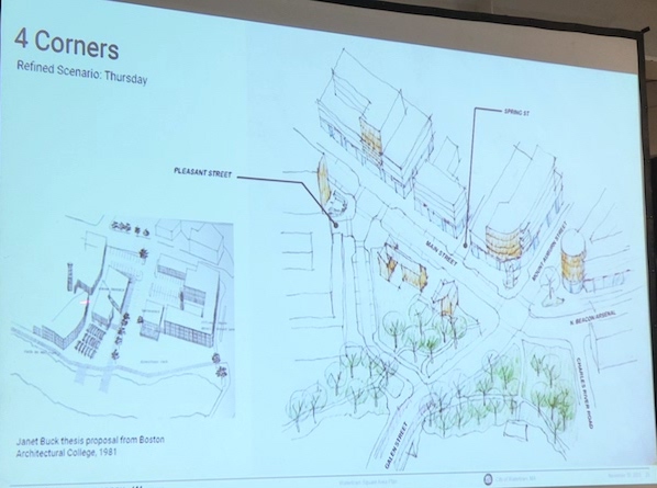
Four Corners
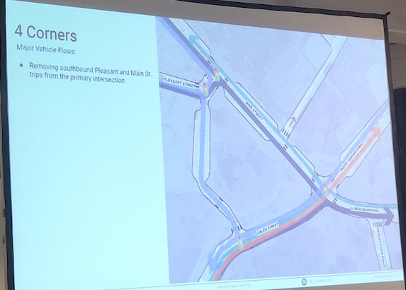
The scenario is dubbed Four Corners because the main intersection would have just four corners, instead of the current five. In this scenario, some of the traffic would be removed from the main Watertown Square intersection by having it turn right off Main Street and Pleasant Street to head south toward Galen Street in the direction of the Mass. Pike. It would use the current bus parking area on the west side of the Delta, and would be one-way south. On Wednesday night, traffic engineers reported that one in three trips through Watertown Square are going to or from the Pike.
Main Street would remain largely unchanged, but it would remove one road from the main intersection: Charles River Road. That would be doglegged at the western end and it would form a T intersection with Arsenal Street, Speck said.
The expanded open space would allow for bicycle and pedestrian paths to link up, which they do not do currently, said Tim Love, from the lead consultant firm, Utile. On the Delta, the Charles River Path would join the bike path on Arsenal Street, which would be extended to the Watertown Square intersection.
Another addition would be small retail buildings on the Delta on Main Street. Speck said that he had heard that the Delta was not buildable land, but said that the retail would go on the newly created land. Street parking would be allowed on the north and west sides of the Delta.
Mini Main Street
The Mini Main Street option was something not developed by designers, but was inspired by a sketch by a resident, Speck said. In this scenario, traffic is almost completely removed from the side of the Delta along Main Street. Only a one-way west road intended for local traffic would go along that stretch. The main flow of vehicles would travel east-west along the road that would go around the south side of the Delta. There would also be a four-way intersection created by linking Mt. Auburn Street and Riverside Street where it hits Arsenal Street.
While the traffic flow looks significantly detoured, Speck said he is confident that people will get used to it.
“There is a misconception that people don’t like to turn,” Speck said. “Drivers don’t like to sit, but cars have steering wheels, buses have steering wheels.”

Along the “Mini Main Street,” which is what Speck called the one-way section, retail would be built on the Delta side, so that there is retail on both sides. He said having some cars on that section would be beneficial because having some traffic, if it moves slowly, would bring some more life to the area.
The sketch that led to Mini Main Street was made by resident Dennis Duff, who said he wanted to create a promenade along the north side of Main Street from City Hall to the Watertown Square intersection by widening the sidewalk on that section.
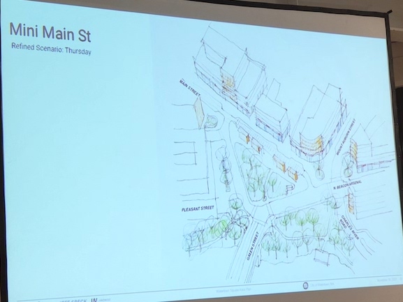
Parallel parking spaces would also be created along Mini Main Street, Love said, for people going to the retail stores and restaurants in the area. More landscaping would be added in the extended plazas created at the corners, Love said. This scenario would also link the Charles River Path across Galen Street and also to the Arsenal Street bike path through the Delta.
By moving traffic south, bus connections would be easier for some lines, said Erin Cameron, a traffic consultant from Stantec. People riding the 70 bus along Main Street would have a shorter distance to walk to Watertown Yard to catch the several lines that run from there, including the 57 and the express buses. On Wednesday, MBTA officials said that they are seriously considering linking the 71 and 57 buses by extending one of the lines across the Galen Street Bridge. On Thursday, consultants said they expect the 71 to be extended to Watertown Yard because the MBTA has plans to build a new bus parking garage there.
Cameron said that in both scenarios, the area would be improved for pedestrians because the street crossings would be much shorter.
Next Steps
Thursday’s meeting ended the three day design charrette, but the process is far from over. Assistant City Manager Steve Magoon said the city officials were pleased with the turnout and the input participants provided, but it will take some time for designers to digest all of the information and test various scenarios.
City Manager George Proakis said he expects the next public meeting, where more detailed plans would be presented, to take place in March. After that the Planning Board and City Council will have to consider and approve zoning changes to allow the changes to both the intersection, and to meet other requirements, such as the MBTA Communities Law zoning to encourage more housing. The City must come up with a plan to meet the requirement by the end of 2024, Proakis said.
Follow Watertown News for more details from the Design Charrette, including more changes to roads in the area, a possible parking garage, and people’s views on creating housing to meet the MBTA Communities Law requirements.
Find out more about the Watertown Square Area Plan at watertownsquareimprovements.com
So let me get this straight, wider sidewalks and less road on main st in watertown? This will alleviate the bumper to bumper traffic every morning heading east?
This is great urban planning since Main St. is backed up from the Square to the police station every morning. I think less road and more sidewalk will really help traffic flow considering the temporary high school is on Main St. and the new developments at Russo’s, Sterritt Lumber and Pleasant street won’t increase traffic on Pleasant St and Main St. according to developers because Bridge St is never crowded with cars so everyone can use that as an alternate way to pike while the streets are narrowed.
In fact let’s put in jersey barriers on Main St as well since all those bikers and motorized scooters need a path and it has worked very well in Cambridge. This would definitely help narrow the road and according to developers most people don’t like their cars.
If Bob Moses were in charge he’d suggest a parkway through Watertown and directly to the Pike….speaking of the inventor of the toll booth….
Another Moses approved suggestion….surge pricing… during rush hour charge 1 in 3 drivers a premium for the priveledge of driving through the Square to get to the Pike.
Problem solved.
Good question. Jeff Speck, one of the urban planner consultants, said that he does not think that traffic can be improved, and if more capacity was built in more people would use it because they would be directed there by Waze or other Google Maps so it would still be congested.
So his focus is more on building a downtown that is more inviting and vibrant, rather than improving the number of cars that get through.
Oh, also there will be improvements to the intersection by making it a 4 way instead of 5 way intersection. That will make light cycles faster.
Bicycles do not lend themselves to retail or industrial betterment, except to the manufacture and sale of same, bolstered by their lobbyists. The name of the game for a capitalist designed society is to continually expand; constraining roadways to make way for bicyclists is absurd. Has any survey been conducted to determine just who and how many utilize bicycles, and the inclement (like snow) whether that restricts that method of transportation? Yes, how many and who; has a demographic study been done by researching the censor reports to determine the gentrification of the city? Are the bicyclists required to obtain a permit or license? Why is there not a requirement for bicycles to be registered, excise taxed, and riders tested to pay for a license, to determine if they understand traffic and pedestrian right of ways? To my knowledge there is currently no attempt to police(yes, police)the activities of bicyclists, nor is any planned. The preconceived notion that disrupting the road ways to create a pie in the sky retail situation in Watertown Square, when there are more than sufficient Malls not more than a few miles down the roadways is extreme wishful thinking. The whole scheme stinks to high heaven of the Greening of America, ie., get rid of motor vehicle traffic, which is the life blood of our society. No one has produced a study of the economic impact of constricting Watertown Square roadway traffic on the outlying communities (Belmont, Arlington, Cambridge, Newton, Wellesley, Needham, Alston/Brighton, Brookline, Boston, and probably many more. Have any of those cities been included in this grandiose effort to ease the way for pedestrian and bicycle traffic that will cripple motor vehicle traffic and impact on their citizens? All I can see at this point is the continuing effort to develop Watertown by wringing every cent of potential construction development funding ~ look around. There is no doubt that the next step in “developing” Watertown is taking property by Immanent Domain.
I couldn’t disagree more. Where do I even start? First of all, I bike year round with my three kids. I do not drive a car at all in Watertown or surrounding towns. So any argument that people cannot bike in cold, snow, or rain to me is completely ridiculous because I’m a living counter example.
Bicycles do not lend themselves to retail? So I guess my entire car-free life just doesn’t count? Do you think I just don’t spend money because I don’t drive a car? On the contrary, because I save so much money by not owning a car, I have a lot more disposable income to spend on local businesses! I do all the normal things — I go to Target, restaurants, grocery shopping, coffee shops, etc. This has been studied repeatedly across the world. The introduction of bike lanes does not negatively affect businesses, an often times it helps them. Here’s a study from 2016 in Toronto: https://www.tcat.ca/wp-content/uploads/2019/08/Bloor-Economic-Impact-Study-Full-Report-updated-2019-09-03.pdf
Why is there no requirement for registering and taxing bikes? Maybe because bikes aren’t 2000 pound machines capable of easily killing people (40,000 Americans per year) or doing severe property damage. Bikes are much closer to pedestrians than they are to cars as is evidenced by the many multi-use paths where bikers and pedestrians co-exist very well together. People like me are not afraid of letting their 5 year old ride their bike on multi-use paths. The amount of danger that a bike poses is at least an order of magnitude less than a car when looking at just momentum alone. Then let’s talk about blind spots–how many children can fit into the blind spot of an F-150? Seems like every year they get taller and heavier.
You talk of policing bikes. Okay, sounds like you will also be very supportive of red-light cameras and speed cameras to police cars more effectively too. I see cars speeding and runnings reds daily, surely you’re in support of better enforcement of those laws too.
If you build road capacity, you attract cars. For example, Texas famously spent billions of dollars to expand the Katy Freeway to absolutely epic proportions and within 5 years traffic was worse than before construction. Induced demand has been studied and detailed for as long as cars have been around. However, induced demand works for other modes of transportation too. So the real question is: which kind of demand do we want to be inducing? I’d argue that the last thing we want to do is encourage private vehicle travel. Private vehicles scale the worst among all transportation options and it has all kinds of negative externalities (pollution, noise, congestion, delays on buses, hazards to pedestrians, to name a few). We need to start replacing car trips with bike trips and Watertown is the perfect place to do that.
Traffic is complex, fluid, and sometimes counter intuitive. Sometimes significant amounts of traffic go away after a road is reduced (sometimes called “traffic evaporation”, there have been significant observed examples from Seoul, NYC, Germany, and other places). Sometimes adding capacity actually slows down traffic (see Braess’s paradox). “Marchetti’s constant” is a finding that people will tend towards 30 minute commutes which means if roadways are widened, it only encourages people to move further away then fill up that capacity.
You bemoan eminent domain yet don’t seem to acknowledge how much eminent domain has been used in the highway-era to take property away in order to give it away to cars. I guess THAT kind of eminent domain is okay? Also, nobody is suggesting taking property by eminent domain, this is just fear mongering.
Hi Scott,
I am sorry but you and your family are the exception to the rule. I know plenty of avid bikers and most will not bike in the snow or on icey roads.
Another thought; what happens in the event of a Mass Evacuation requirement? The flow of motor vehicle traffic through Watertown Square would be horrific. We live in perilous times, and always will, whether pronounced or latent. Primary examples are the lack of the capability to manufacture the basic instruments of war, ie., artillery shells, ammunition, naval ships, and so forth; Europe is now paying the price, ie., Germany indicates that if will not be able to rebuild its crumbling artillery capacity, including training bases, until 2040 ~ are they serious? Are not the Germans the economic and manufacturing king of Europe?
Oh I forgot, their population has been fully integrated without restriction with non-European individuals that do not share the language or culture. The current unpleasantness between Ukraine and Russia is the tip of the proverbial nightmare; consider the current state of the Armed F0rces of the United States ~ oh, you do not know? And then there are the millions of recent arrivals within the United States that are crushing resources within our major cities ~ oh, you are not aware of that? Oh, did I forget the insurrectionist-like crime problems that no one seems to be able to control? There are many other reasons not to constrict/restrict motor vehicle traffic through Watertown Square ~ think outside of the proverbial box. =|=
Both of these designs seem intent on easing traffic flow on Pleasant Street. It recognizes reality that all the developments on Pleasant have created this congestion nightmare. However, under the mini-option, the traffic from Galen (exiting the Pike) into Watertown Center is repelled from going left and is instead diverted anywhere/everywhere. I routinely use that left turn onto Main after exiting the Pike. The only option I support would be four corners but if the majority of people prefer the other one, so be it.
Mr Ferson – I attended the design charrette and Pleasant St. was not the focus of the 2 day session. The session was about re-imagining how cars, busses, bikes, people/children and wheelchairs can all SHARE the public spaces in our city center. It’s “our” city center, and right now it’s designed to serve cars and busses only.
Also, the Mini Main St. option would *not* prevent someone from going left while traveling north on Galen St. … the drawing includes 2-way traffic on the leg where the restricted bus lane is now, and left turns from Galen would be regulated by a stoplight (which is not yet drawn on the diagram).
Sent from my iPad
Begin forwarded message:
From: Joseph MacDonald
Date: December 5, 2023 at 9:40:24 AM EST
To: JOE MAC DONALD
Subject: Watertown Square Disaster
I have lived in Watertown all my life and I have lived in Watertown Square for the past 54 years. The only major traffic problems I see is during the commuting periods of 7-9 AM and 4-6 PM. Most of the problem stems from cars blocking the intersections so those with the green light can’t go through. Years back a police officer was stationed during these hours at the intersections of Arsenal / North Beacon, Main / Arsenal and Galen over the Bridge to prevent gridlock. Also to shrink traffic lanes for bicycle lanes only backs up the traffic lanes and causes more gridlock (see Charles River Road entering the square!). There is plenty of room for 2 vehicles but one lane has been sacrificed for a bike lane. I don’t see many bikes using that lane at any time of the day and those that do don’t obey the traffic signals. If people want to avoid the square let them. Don’t force them to detour through the neighborhoods. After this so-called improvement is done the experts will take their money, leave us with the mess and move on to their next project.
Sent from my iPad