
WorldTech Engineering
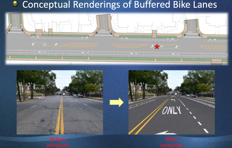
An illustration of what Mt. Auburn Street could look like if a “road diet” is used. It would reduce the traffic lanes to one each way, add bike lanes with buffers and add left turn pockets.
The latest proposal for the major overhaul of Mt. Auburn Street was unveiled by traffic engineers at Monday night’s Public Works subcommittee meeting, and they were largely met with skepticism and disappointment.
The first detailed draft of what the redesigned Mt. Auburn Street could or would look like was presented in June by the traffic engineers from WorldTech Engineering. It included removal of lanes, called a “road diet” in some areas and added bike lanes along the roadway.
Monday night’s presentation included recommendations that had fewer areas where the road diet would be used and fewer areas with dedicated bike lanes.
Project designers have split the road into four sections (from West to East):
Patten Street to Walnut Street
Walnut Street to Dexter Avenue
Dexter Avenue to Arlington Street (Coolidge Square)
Arlington Street to the Cambridge line
The least amount of change would be seen in the area closest to Watertown Square where two-lanes each way is proposed to be kept, and no dedicated bike lanes. The engineers proposed having “share the roadway” arrows painted on the road to show where bikes can go.
The Walnut to Dexter section would have some major changes, including narrowing to one lane of traffic each way, adding left turn “pockets” for a majority of un-signaled intersections. A new traffic light has been proposed at Boylston Street to help with traffic and walkers coming from Hosmer School.
WorldTech Engineering
An illustration showing details of what a street with buffered bike lanes would look like. This is proposed for the area between Walnut Street and Dexter Avenue.
The proposal for Coolidge Square (Dexter to Arlington) has not been completed by engineers. They plan a meeting in January focusing just on that section where a map of the entire stretch will be rolled out so people can see the proposal and give detailed comments and questions. Engineers did note that businesses in the area need a place for trucks to unload, that the sidewalks are narrow in some places due to trees and utility poles, and that parking stalls need to be 8 feet wide because it is zoned as a limited business district.
Engineers are also still working on design of the section from Arlington to the Cambridge line. The area is wider than other sections and has fewer driveways so it was considered for a separated bike lane (up on sidewalk level) on both sides. This will not work, but they may have separated bike lane on one side and one on the street level on the other. They also are considering making a “bus stop island” in front of Tufts Health Plan where a bike lane would pass behind the bus stop shelter.
Bike Lanes and Pedestrians
The June meeting was a joint meeting with the Public Works Committee and the Bicycle and Pedestrian Committee, and engineers included a lot of details about bike lane options. This continued in Monday’s meeting.
Three types of bike lanes were considered:
Separated – where the bike lane is at the level with the sidewalk and separated from the traffic and parking
Protected – where bicycles travel on street level, but the lane is protected from traffic by the row of parked cars. It would also be right next to the curb.
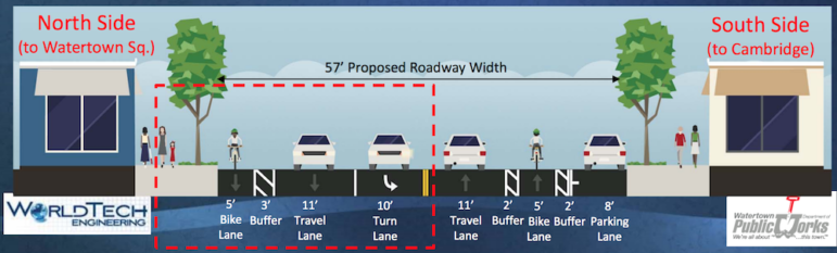
Buffered – which has the bicycles on the street level between the parked cars and traffic. Engineers proposed having 2-foot painted buffers between both the traffic and the parked cars.
Separated bike lanes are only being considered for one side of the road in the Arlington Street to the Cambridge line section. The other side would be a buffered bike lane.
Buffered bike lanes have been proposed for the north and south sides of the Walnut to Dexter section. There would be a 2-foot buffer on both sides on the south side, and on the north side, where there is no parking so there would be a buffer between traffic and the curb would be on the other side.
No bike lanes have been proposed from Patten to Walnut, and the Coolidge Square section is still being designed.
Protected bike lanes were largely ruled out because there are issues with bicycles being visible to drivers because they are behind parked cars, and also because it would not leave space for cars to pull over for emergency vehicles or to go around a stalled bus or accident.
Bumpouts, where the sidewalk is pushed further into the road, have been proposed at intersections to allow pedestrians to cross more easily and safely.
Concerns from Council and Public
Several residents said they did not think that Mt. Auburn Street could handle all the traffic it has, plus the addition of vehicles from the new apartments in town if the number of lanes is reduced.
Mohammad Tahmili, who owns Tabrizi Bakery in Watertown Square, said it can take 45 minutes to get from the Mass Pike to the Square if he arrives at 8:30 a.m. He fears this will get worse with a road diet.
Mike Athanas, who owns The W Pizza, echoed his concerns.
“I am disappointed to see one lane of traffic in some ares,” Athanas said. “Traffic is currently tremendous.”
The project has been compared to the redesign of Belmont Street/Trapelo Road, which narrowed some areas to one lane each way and added bumpouts at intersections. Athanas said that he didn’t like that project, and said it has been a problem for property owners with a bumpouts in front because it means shoveling a much wider sidewalk.
State Sen. Will Brownsberger said he worked on the Belmont/Trapelo project first as a Belmont Selectman and then as a State Rep. and Senator. He said he likes how it turned out.
“I am a user of Trapelo/Belmont. I live on a side street and drive it from time to time, I bike it frequently, I walk it and I take the bus on it,” Brownsberger said. “Overall, I think it is vastly improved.”
The road diet will only be used if it can handle 17,000 cars a day, plus 5,000 bus passengers, said Kris Surette of WorldTech. The traffic measured in 2010 showed most major intersections on Mt. Auburn Street well in excess of 17,000. Traffic engineers are also including traffic anticipated to come from the new apartments and developments in Watertown.
Erica Dorenkamp, who lives near Hosmer School, said she welcomes reducing the roadway to one lane each way.
“It would slow traffic down,” Dorenkamp said. “It is scary to ride a bike for me, and there is no way I would let kids bike on it.”
Tony Physic, a Watertown Police officer who was giving his personal thoughts, said he worries about emergency vehicles getting by if there are only one lane each way.
“People are afraid to go into bike lanes, so (police and fire vehicles) have to get into oncoming traffic to go around,” Physic said.
Mal Atamian, who owns a business in Coolidge Square, said the area needs parking and to maintain two lanes each way because many businesses do not have a loading area in the back so trucks must stop on Mt. Auburn Street.
Councilor Aaron Dushku, who chairs the Public Works Committee, said that it is not safe to bike on Mt. Auburn Street, and he was disappointed to see that the separated bike lanes will not be added.
Councilor Lisa Feltner, who represents District B – which includes the part of Mt. Auburn Street closer to Watertown Square, said she has many problems with the design. She said it is not being designed in conjunction with other major projects, such as the Watertown Square redesign and the Arsenal Street Corridor project.
“Traffic is being shoved onto Irving Street. Irving seems to be the solution for everything,” Feltner said. “I am concerned about that and this is not a holistic look at Watertown Square.”
Feltner added that she lives on a side street off Mt. Auburn right near the Square and it is tough to get in and out already, and there is a proposal to make Parker Street one way which would make it harder to get out of that neighborhood.
In addition, she is concerned about a proposal to remove parking from Mt. Auburn Street in front of businesses between Phillips Street to Chester Street, which is across from where Common Street hits Mt. Auburn. Side streets are already overwhelmed by people parking on their street, Feltner said.
Councilor Tony Palomba said he is concerned about the direction of the project, and worries that it will not be able to handle the “exploding development” in Watertown.
“I’m taking a step back on this project,” Palmoba said. “There seem to be significant issues that need to be addressed.”
Dushku said he believes the designers should keep working and take into account the comments from the meeting and left on the project website.
“I don’t think we should hold up the project,” Dushku said. “(Designers) should keep doing what they are doing. They will focus on Coolidge Square next.”
The meeting on Coolidge Square will take place in January, and a draft plan will be put up on the Mount Auburn Street Project website in February and a more informal, “open house” meeting will be held in February or March to discuss the draft.
The goal of the town is to get the project on the State’s transportation project list in Fiscal Year 2022.
Comments on the Mount Auburn Street Project can be left here: https://mountauburnstreet.com/stay-in-touch/
Project documents can be found here: https://mountauburnstreet.com/documents/
See previous stories on the project:
Protected Bike Lanes Included in Plans for Mt. Auburn Street Renovation
Planned ‘Road Diet’ for Mt. Auburn Street Gets Mixed Reviews
Narrowing Mt. Auburn Street is not a good idea. Shoppers opening their car doors to shop is bad for community and businesses. I almost hit a car door opening on Arsenal Street. It is a very dangerous idea for people. Traffic lights are enough. Concentrate on safety and paving the streets of Watertown and ideas for expanding our schools. Arsenal Street is a disaster in my eyes. Thank God I know the back roads and back streets of Watertown to dodge the already existing traffic. Don’t make it worse. Make it safe. Nobody will shop because of the traffic….trust me.
Total insanity to accommodate bikes…. Basically they want to force us all out of cars and back into the stone age.
John, it is only necessary to whisper the word “bicycle” to put you in a lather. So you hate bikes–who cares. Many of your townsfolk use bikes to get around and if trends continue, increasing numbers will do so in the future. Massachusetts state law gives bikes access to all non-resctricted roads. As it is now, Mt. Auburn Street is very unsafe for bicycle traffic. So something must be done. I am not sure that this plan is the correct thing, as this is a difficult problem to solve.
Don’t look now John, but I think that you are living in the stone age.
I am a biker and rollerblader who has been using Mt. Auburn St. and other main streets for 30 years. I feel we, as bikers are best served if we have a designated shared right lane closest to the sidewalk. Automotive Traffic needs are already very demanding and pretending it’s not is selfish and economically impractical. Markings that bikers and cars share the road seems to be the best practical solution unless we want to share the walk ways which I am also in favor of. I often use the sidewalks for biking when I’m on Mt. Auburn. It is far safer and there aren’t many people who use the sidewalk for walking and when they do it’s easy to ask for room by saying “on your left” as most biker do when they are going past walkers say on the “bike path” along the Charles.
This desire by some to make are main arteries the same as side streets is harmful to us all. Arsenal St. is far more dangerous now than before the narrow section was created. Someone is bound to get hurt there or a car door get’s taken off.
We must not pretend our main roads are not meant to be efficient means to get around town. Side roads, safety and economics will be diminished for all of us.
Mr. Brownsberger, I can understand how you are happy with how Trapelo rd. turned out for you as you live there and would like to pretend that that area is not a main rd. For everyone who needs that main road to get around it is Not an improvement. I see it’s an example of the use of public funds for selfish desires at the expense of the public good. I wonder, under your logic of the Trapelo Rd. “improvements” it would seem all main roads should be treated as secondary roads?
Also, Please return the right turn on red that worked just fine at the corner Trapelo/Belmont. It’s waists time and gas that does not need to happen. Right turn worked fine for many many decades.
Thanks
Glad to see this, this is a safety improvement and a multimodal improvement. With 80,000 more cars going onto our streets in the next decade, we need to look to other solutions. Glad Watertown is moving in the right direction.
I don’t understand the bike lanes block emergency vehicles argument? In those situations I dismount and move to the sidewalk to give space for cars (and move myself out of danger for those who don’t think to check before moving over). Cars not moving is unrelated to bikes. Maybe it’s a driver ed issue? Wouldn’t hurt to put people through a more rigorous training and update that training with the times. For many people, bikes weren’t as prevalent when they started driving. Increased education could do wonders. Also safe spaces for all is always a good idea. Don’t punish me because I need a bike to commute around because I don’t have the privilege of owning a car.
I have great skepticism about dieting Mt. Auburn Street down to a single lane. I am concerned that it will have a negative impact on our bus transit, which is already marginally unreliable.
Versions of the plan that I have seen contain many features I deem problematic, particularly as relates to bus transit.
While I would like to see drivers operating at lower speeds (there is too much dangerous speeding in my neighborhood) I would also like to see them (and everyone else) have shorter trip times. This means that coordinating signals is essential. And we must have signal priority on our buses as soon as possible.
Mt. Auburn Street is neither a backroad nor a super highway. It is a main artery of our town and a back bone of several business districts. It is a street that is is residential and connects residential neighborhoods. Thus safety must be a primary concern.
Cycling is growing as a means of transportation and will continue to do so. That is good, as it reduces vehicular traffic and makes people healthier. But Mt. Auburn Street is not currently safe for cyclists in many areas. Good cycling facilities will only help the future of our community. In ten years, the number of cycling commuters will be close to equal to the number of driving commuters. We must plan accordingly.
We must accommodate cars, trucks, bicycles and pedestrians. Reducing single occupancy vehicular traffic would be beneficial to all these groups, including those who must drive. The best way to do that in large numbers is to provide more and more efficient public transit.
It is certain that Mt. Auburn Street needs an update. But the plan at present is not the answer. This process should proceed slowly and deliberately with plenty of opportunity for public comment.
We must bring our best ideas to the table. We must figure out the best solutions for our community–all of our community: driver, transit users, cyclists and pedestrians. The planners must be open to ideas from the public–after all, it is they who use this street on a daily basis. We must plan for the future, rather than be content with the present or wallow in the past. This is an opportunity for improvement and it must be done right.
Despite what the biking community desires and wishes are; we are not Seattle, or Portland, or Amsterdam or any other wannabe ‘fossil fuel free’ oasis/paradise. Things may or may not be working just fine with the current situation, but there is no conceivable way that this proposal will improve what’s coming down the road.
If I understand things correctly, the “road diet” will only be feasible if Mt. Auburn St. can accommodate 17,000 vehicles and 5,000 public transit users, yet the 2010 traffic survey indicates that there were roughly, 20,000 vehicles passing through on a daily basis… and that was 7 years ago. What are the figures for 2017? Also factor in that the project is slated to begin 5 years from now, add in 1-2-3 years to complete it. How many more additional vehicles can we expect in that time frame? Yet there is a small but vocal subset that thinks the solution is reducing the number of travel lanes by half. Does any of this make any sense to anyone?
In any of these traffic studies, has anyone determined the current number of cyclists using Mt. Auburn St? Has anyone projected the number of how many more people will be bicycling if this project goes through? This should be relevant in determining if the project’s goals justify’s its purpose.
I was present at Monday nights meeting, and one concern that stood out for me was the commentary from Officer Physic, namely that if there is a traffic accident (and depending on the severity of the accident), one or both sides of the street will be shut down… let that sink in for a moment.
And the best is yet to come, just wait until they unveil their master plan for Coolidge Square. I can’t wait to see what lunacy they have up their sleeves for that one.
The World tech presentation only offered three options: Buffered bike lanes, separated bike lanes and protected bike lanes; all which would require reducing the number of travel lanes for vehicles. I’m guessing it’s unreasonable, unthinkable for them to consider a 4’th option; that is posted signage with sharrow markings on the roadway.
My understanding from a comment posted in an earlier article, doing so would still meet the Federal requirement for accommodating bicyclists along with regular vehicular traffic. To me, that’s reasonable.
With that in mind, I’d like to see see some commentary from those on the Bike-Ped committee posted here to explain, defend and justify the need for this project. The one person at the meeting (the Bike-Ped chairman), that did speak, didn’t really have anything constructive to offer.
This battle is far, far from over… it’s just beginning. Keeping the heat on town officials is the way to go.
Thanks for your comment, John. I would add that the bike lanes and the road diet did not start with the Bicycle and Pedestrian Committee. Though they have advocated for more protected bike lanes on the road. The plan for going to one lane has been out there since 2010, I believe, and the Bike & Ped really started giving its input in 2016.
John, are you basically saying that you don’t care about the safety of the cyclists that use Mt. Auburn Street? The laws of the Commonwealth give cyclists equal access to the roads. It only follows that their safety must be protected. Are you willing to accept fatalities involving your neighbor cyclists as just a necessary evil?
Please also explain to me why you refer to this issue as a battle. Who exactly is the enemy?
While I have said that I am skeptical about the road diet, I also see the need to protect cyclists on Mt. Auburn Street. Not sure that sharrows are enough.
“John, are you basically saying that you don’t care about the safety of the cyclists that use Mt. Auburn Street? The laws of the Commonwealth give cyclists equal access to the roads. It only follows that their safety must be protected. Are you willing to accept fatalities involving your neighbor cyclists as just a necessary evil?”
We all face certain risks anytime we step out the door. When one willingly chooses one mode of transportation over another, they do so knowing what risks and inconveniences are associated with it. A personal example of mine: My old daily driver was a Ford E250 van… the thing was huge! I knew at the time it was impractical, gas mileage was horrible, it was useless in the snow, parking choices were limited, couldn’t fit in a parking garage, etc, yet I was willing to accept that, and didn’t think for one moment that I should subject others to my needs or problems . Think riding a bicycle can be dangerous? Try riding a motorcycle for a few years… again, same thing. One either has to accept certain risks and inconveniences that come with the territory or find some other way to get around.
“Accept fatalities”? Look at what’s been done (and being done), on Arsenal St
west of School St. It’s only a matter of time before there’s a serious accident with injuries happens along there. What about the health and safety risks to others if there’s a delayed response from police, fire, EMS because they have difficulties making their way through backed up traffic?
“Don’t care”? What about the cyclists that have no regard for their own safety?… running red lights and stop signs, riding without reflective gear, riding at night with no lights, etc. Why should I care for someone who doesn’t even care for their own safety or the safety of others?
Yes, Mt. Auburn St. might seem dangerous, but so are the side streets cyclists use to get to and from it. Should we make any alterations to them too?
I’m not saying we should ignore obstacles that are clearly dangerous, bicycling on city streets is inherently risky and dangerous, if that’s ones choice, so be it, just don’t force your choice on others and expect us to willingly accept it. We can strive to make things safer, but one can only go so
far until it becomes impractical. Reducing Mt. Auburn St. to two lanes is a perfect example.
“Equal access”? What’s equal about surrendering 50% of the roadway to 3% of the population? Not only is it unfair, its a poor use of limited resources and infrastructure that except for the hard core cyclist, is only going to be used 8-9 months out of the year. From some of your previous comments, you
seem to have concerns about public transit. What’s going to happen when there’s an accident on Mt. Auburn, the police shut down a section and diverts traffic to the residential side roads… where are the trackless trolleys
going to go?
“Please also explain to me why you refer to this issue as a battle. Who exactly is the enemy?”
Because it is a a battle… a battle for common sense and the direction this town is headed in.
Enemy = the opposition… those that would advance this agenda over everything else.
The more this becomes public, and residents begin to fully understand whats at stake here, perhaps more people will get involved… and that means attending meetings, contacting their Town Council members, not
holding back, not getting apathetic because they develop the attitude that ‘it doesn’t matter what I say or do, they’ll vote it in anyways’.
“While I have said that I am skeptical about the road diet, I also see the need to protect cyclists on Mt. Auburn Street.
“Not sure that sharrows are enough”.
They seem good enough for the stretch from Patten St. to Watertown Square, Bigelow Ave to Arlington St. and other roads in town. When it comes down to it, there are really only 3 options available: Separate bike lanes, share the road,, and not going through with this at all. Obviously you already know where I do not stand.
Sorry for my long winded rant, but I’m always like that
Seems like you have confirmed my worst fears, John.
The plan doesn’t allocate 50% of the road to bicycles. The design calls for 2 5-foot bike lanes in a 57-foot wide road. That’s about 18% of the available width. There will continue to be 2 11-foot travel lanes, a 10-foot turning lane, and an 8-foot parking lane dedicated to automobile traffic.
The plan also does not call for the width of the paved surface to be reduced. In the event of an emergency requiring a section of the road to be closed, neither a bike lane nor a left turn only arrow painted on the road will prevent the police from directing traffic around the affected area.
Thank you for a very clear explanation of the plan and what should happen in the event of an accident or emergency. Based on his comments at the meeting, it is clear that Officer Physic didn’t understand what was being presented.
I disagree. I believe Officer Physic was explaining what he has nitoced as an officer that drivers don’t use bike lanes to move over, even though it is allowed. As someone said, maybe that could ve something that people are educated to do when emergency vehicles are coming.
Your 18% figure is woefully wrong, it’s more than a 5′ bike lane when the two 2′ buffers on either side are included (or one 3′ buffer), which makes it 8′ or 9′ overall.
Regardless, the overall available surface width is irrelevant, whats at issue here is the reduction in the number of available travel lanes.
If 50% of the travel lanes are taken away (the 10′ left turn lane is not a travel lane nor is the 8′ parking lane), and reallocated solely for bicycle use, that’s 50% of travel lanes that was once allocated for motor vehicles (and cyclists), that is now being used exclusively by cyclists.
As far as diverting traffic at accident scenes… the police WILL detour and direct traffic to the side streets.
How a trackless trolley (or even an MBTA bus), will be able to do that, I’d like to know. I don’t know if you were in attendance at Monday nights meeting or not, but Officer Physic told it like
it is… if there’s a situation that requires the response of police/fire/EMS, they WILL shut down BOTH lanes if necessary for safety reasons. Who do you think is going to take the heat or cursed out for that… the Bike-Ped Committee?
A reminder, only one comment per story if you are not using your full name.
Adam,
If you reduce a 4 lane road to 2 that’s 50%
Also – n 8 ft. parking lane on a main road is not wide enough!
Just look at the disaster on Arsenal St. I’m in fear every time I have to travel down Arsenal St. after it becomes 1 lane. That narrow section was an undeniably irresponsible idea that never should have been done.
The one caveat is that the sidewalk and bike lane are together. But aside from that, the road is too narrow for the safety of drivers and the parked cars.
Bike lanes and sidewalks combinations are the only solution. I do it all the time. I ride on the sidewalk where riding in the street is impractical. Like going from school street to common St. There is almost never anyone on the sidewalks anyway.
Do you have a car? Have you ever had your mirror clipped off. I have. Too many time to count. Our streets are already too narrow. Many of them should be one ways but no one has the sense to look at that and make the hard choices.
I think that you nailed your response for commonsense instead of biased thinking.
They’ve been involved with the project in one way or another since at least 2003.
I don’t know just how actively they’ve been involved between then and now, but as far as their more recent, visible participation and involvement goes, I think that has more to do with finally getting down to holding public meetings and working towards the 25% design plan goal.
“BICYCLE TRANSPORTATION PLAN
TOWN OF WATERTOWN
WATERTOWN BICYCLE COMMITTEE
July 18, 2003
This Bicycle Transportation Plan was prepared in coordination with the Watertown Bicycle Committee and the Watertown Department of Public Works.
Study corridors have been provided by the Watertown Bicycle Committee. A summary of recommendations for improved bicycle accommodations follows:
5. Mt. Auburn Street – Study the potential for eliminating one travel lane in each direction. If a lane reduction is feasible, stripe two 14 foot travel lanes with two eight foot parking lanes and two five foot bike lanes offset one foot from the parking lane. Sign for Bike Lanes.
6. Mt. Auburn Street – (commercial district) – Study the potential for eliminating one
travel lane in each direction. If a lane reduction is feasible, stripe two 14 foot travel
lanes with two eight foot parking lanes and two five foot bike lanes offset one foot from
the parking lane. Sign for Bike Lanes”
Source: http://www.watertown-ma.gov/DocumentCenter/View/15633
And they sent a letter of support to the Town Council in May, 2011…
“Watertown Bi-Ped Committee Minutes May 2011
Mt. Auburn Street design
Sheila working on letter of support”
Source… http://www.watertown-ma.gov/ArchiveCenter/ViewFile/Item/1447
The minutes and agendas for the Bike-Ped committee are posted on the towns website
(the minutes from May 2017 to the present aren’t posted for some reason). There are too many to go through in one sitting, but even from reading random minutes and agendas, its often the case that Mt. Auburn St. will be mentioned.
http://www.watertown-ma.gov/Archive.aspx?AMID=81
http://www.watertown-ma.gov/Archive.aspx?AMID=83
Thanks. That’s good info.
A road diet will be a win for everyone. Pedestrians will have fewer lanes to cross, making it much safer. Wider sidewalks will make it more pleasant to walk and will benefit local business by creating more room for customers to walk and space for outdoor seating and sidewalk cafes. Bike lanes will make it much more appealing for families and people of all ages to bike, and will make it easier for drivers to navigate since they won’t have to be sharing a lane with bicyclists as often. A single through lane each direction will allow for left turn pockets along the street, making it much easier and safer to turn left from Mt Auburn. Fewer lanes will also make it much easier to turn onto Mt Auburn from side streets and driveways.
Note that while it may seem like 4 lanes would be worse for traffic than 3, that’s not the case for streets up to 26,000 cars per day. This document from the Federal Highway Administration explains why:
https://safety.fhwa.dot.gov/road_diets/resources/pdf/roadDiet_MythBuster.pdf
Putting Mt Auburn Street on a road diet will transform a road designed only for cars into a streetscape designed for all road users. The street calming elements introduced will slow traffic speeds, make Mt Auburn St safer for pedestrians, and will encourage many more people to bicycle. The important question to ask is who are we designing out streets for, for those who live in and love our towns, or for those people who are just commuting through?
“Comment on November 26, 2017 at 4:06 PM said:
Thank you for a very clear explanation of the plan and what should happen in the event of an accident or emergency. Based on his comments at the meeting, it is clear that Officer Physic didn’t understand what was being presented.”
But you do
“I disagree. I believe Officer Physic was explaining what he has nitoced as an officer that drivers don’t use bike lanes to move over, even though it is allowed. As someone said, maybe that could ve something that people are educated to do when emergency vehicles are coming.”
Officer Physic made it quite clear that he was only speaking for himself and not there to represent the position of the WPD position in any way, shape or form, but from Monday nights presentation that “reviewed concepts with Watertown Fire & Police Departments” leaves me wondering what their position/opinion is?
I’m not just asking about the opinions of the chiefs and upper echelons, but also the input of the rank and file/front line people, unions is as well.
As a retired, former 28 year fire department veteran, I’d be shocked if either or have any support for this.
I am a current Firefighter in Watertown. This is going to slow response times for PD and FD vehicles. I see nothing good coming from that. More buildings, more people, more cars, cutting roads in half is a recipe for many potential tragedy’s. How can anyone not take the word of a working police officer? Officer Physic has been doing this for 30+ years. Trust me, he knows what he is talking about.
Would be interested to know how many of the councilors (and state reps/senators) regularly ride on the 71 bus themselves. Ditto how many of them try to drive from Coolidge Sq. to Galen St. or v.v. during rush and school-release hours.
It should be great to narrow the street, put in some more lights too.
It’ll be like trying to get around fresh pond. Anybody notice how it takes 10 times longer or more to get from Huron Ave. to Alewife. That’s what will happen for all drivers and public commuters on Mt Auburn if there is a road diet. The 71 bus is already the worst bus service I have ever had the misfortune of needing to use.
But that’s OK, We will all have the luxury of time to be able to ride our bikes to and from work and the store and any other places we may need to go. I’m going to put a sail on my bike too so I can use wind power. You will have a lane for me for that too won’t you… Maybe down the middle, right between those nice yellow lines. Nobody’s using those right?