Around Town
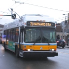
Queue Jump Lanes Added to Mt. Auburn Street in Effort to Improve Bus Service
|
The following information was provided by the Department of Public Works:
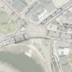
Following days of initial testing, the Town of Watertown has debuted two “queue jump” lanes at School Street and Walnut Street. Queue jump lanes allow buses to move more quickly through intersections by “jumping” to the front of a line of traffic. Bus rapid transit (BRT) systems around the world use queue jump lanes to create a faster and more reliable bus ride and improve overall traffic flow. “Roughly 5,000 bus trips are made each day in Watertown in this corridor, and the Route 71 bus is an important asset to the community,” said Matthew Shuman, Town Engineer for the Town of Watertown. “We also know from research in other places that moving Watertown closer to BRT with queue jump lanes has the potential to speed up the commute for everyone by separating buses from cars at intersections.